InfoGraphic: The Main Weather News Highlights across NZ: Thu, Fri, Sat
22/06/2017 2:57am

> From the WeatherWatch archives
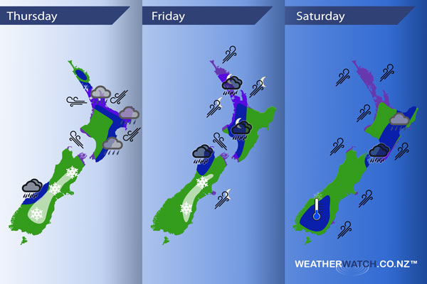
A cold front combines with a warm front coming out of a low in the Tasman Sea today over central South Island regions and delivers some warm advection snow to inland areas. Meanwhile an occluded front moves southwards over the North Island. A low pressure system moves over the North Island on Friday with an easterly quarter airflow over the country tending southwest later in the day. Strong cold southwesterlies ease over New Zealand during Saturday, a weaker cold front moves onto the lower South Island late afternoon.
Thursday
Blue – Areas of drizzle and heavy rain / showers ease about Auckland and the Waikato afternoon onwards, perhaps more towards evening for the Bay Of Plenty. For the east coast of the North Island rain / showers becoming heavy by midday.
In the afternoon heavy showers / downpours may develop about Northland, perhaps even a thunderstorm then easing in the evening – most out at sea now.
Morning heavy rain / showers eases about South Westland.
White – Warm advection snow sets up about the inner South Island from North Otago this morning through to North Canterbury afternoon onwards. Snow isn’t looking overly heavy however it will still be of concern to travellers and farmers, ski fields will be welcoming of the snow.
Snow lowering to 400m about North Otago / South Canterbury this morning although it may back off from afternoon in terms of intensity however the air will still be cold. Starting out higher about Mid Canterbury then lowering to 500m in the afternoon. Snow lowering to 600m about North Canterbury by evening.
Purple – Gusty easterly quarter winds for North Island regions, mostly easing from afternoon. Strong southeasterlies with a risk of gales developing through Cook Strait afternoon onwards.
Friday
Blue – Rain may be heavy about Buller / Tasman during the day then easing in the evening. Overnight as a strong southwesterly airflow develops there may be some heavy rain about western North Island regions.
White – Snow flurries continue about the interior of the South Island for much of the day. However the levels will be higher. Falling to about 500m in the morning about South Canterbury / North Otago, 800m for North Canterbury, lifting above 1000m in the afternoon about North Canterbury and lifting above 1000m overnight further south before clearing.
Purple – Strong southeasterlies through Cook Strait tend more southerly at night. A strong southwesterly airflow develops about Northland in the afternoon then spreading southwards into Auckland, Waikato and Bay Of Plenty overnight. Southwesterlies may gust to gale at times especially about coastal areas in the west.
Overnight gusty southwesterlies develop about outer parts of Banks Peninsula also.
Saturday
Blue – Heavy rain / showers about southern and eastern parts of the North Island ease in the evening.
A frosty start about the far south of the South Island due to a ridge of high pressure, it may dip as low as -3 or -4 degrees celsius first thing.
Purple – A strong southwesterly airflow brings a risk of gales, especially about western parts of the upper North Island. Easing later in the day.
– Please note, the idea behind this update is to focus on the main weather highlights, which is why not all regions are mentioned.
For specific 10 day information for your city, town, rural community or island please see the 1500 forecasts on our homepage!
– Aaron Wilkinson, WeatherWatch.co.nz
Latest Video

Wintry weather coming: Snow, rain, wind & sunshine
A cold front is moving into NZ from Friday to Sunday with low pressure developing west of NZ and then…
Related Articles

Polar airflow + northern low = pockets of heavy rain & snow
A colder change is coming – and so too is a large low which will develop and grow over northern…
Wintry weather coming: Snow, rain, wind & sunshine
A cold front is moving into NZ from Friday to Sunday with low pressure developing west of NZ and then…

ClimateWatch: JULY outlook & what El Niño means for NZ
El Niño is officially here and still getting stronger in the months ahead, but it’s harder to notice its effects…

