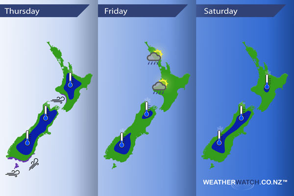
InfoGraphic: The Main Weather News Highlights across NZ: Thu, Fri, Sat
14/06/2017 7:00pm

> From the WeatherWatch archives
A west to northwesterly airflow increases ahead of a southwest front which moves onto the lower South Island late afternoon. This front moves northwards reaching the lower North Island overnight, weakening as it goes. A southwesterly airflow eases on Friday as a large high sits in the Tasman Sea, this high moves over the country on Saturday.
Thursday
Blue – A frosty start for most regions away from the coast, temperatures starting out at -2 to 0 degrees celsius for the inner North Island. Temperatures may dip to -4 degrees for isolated parts of the inner South Island (Pukaki / Twizel comes to mind).
Purple – West to northwest winds build about coastal parts of the lower South Island in the morning, winds may gust to gale through Foveaux strait then changing southwest early afternoon where winds could be strong especially about coastal Otago.
Gusty westerlies build about some central parts of New Zealand in the afternoon, easing overnight.
Friday
Blue – Areas of cloud prevent any reasonable frosts on Friday morning however it may still start the day around 0 degrees for the shaded in areas below. A chance if skies are clear of -2 about Central Otago.
A few showers feed onto the western side of the North Island during the day.
Saturday
Blue – A large high brings mainly settled conditions, a tad cool to start the day for inland areas. No severe frosts, temperatures ranging from +1 to -2 for the shaded areas below.
– Please note, the idea behind this update is to focus on the main weather highlights, which is why not all regions are mentioned.
For specific 10 day information for your city, town, rural community or island please see the 1500 forecasts on our homepage!
– Aaron Wilkinson, WeatherWatch.co.nz
Latest Video

Cold weekend, frosts return with high pressure, then a low late next week
The subantarctic airflow spreads over NZ today/tonight and into Saturday, dropping temperatures nationwide. Snow flurries are possible today to lower…
Related Articles
Cold weekend, frosts return with high pressure, then a low late next week
The subantarctic airflow spreads over NZ today/tonight and into Saturday, dropping temperatures nationwide. Snow flurries are possible today to lower…

Wintry burst of weather: Snow, squally showers then sunshine & frosts
A polar change (another one!) arrives on Friday for the South Island and goes nationwide on Saturday, leaving NZ under…

Antarctic southerly for parts of NZ Fri & Sat
For the first time this year a southerly from off Antarctica is heading towards the South Island, followed by more…

