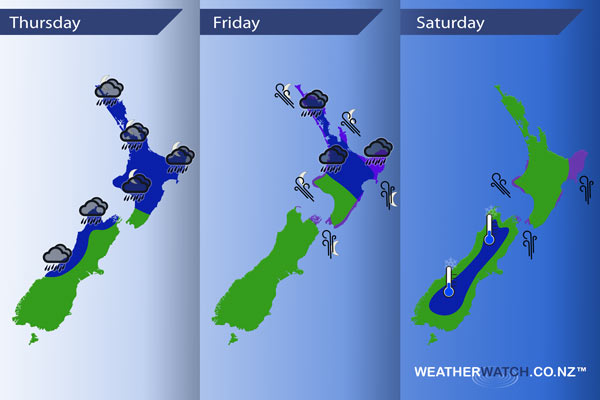
InfoGraphic: The Main Weather News Highlights across NZ: Thu, Fri, Sat
10/05/2017 7:00pm

> From the WeatherWatch archives
A frontal system moves from west to east over the South Island this morning then the North Island later in the day / overnight, meanwhile ex TC Donna positions itself just north of the North Island overnight. A southerly airflow spreads over much of the country on Friday while ex TC Donna moves southeast just of the northeastern side of the North Island during the day, a high pushes in on Saturday while ex TC Donna moves away to the east.
Thursday
Blue – Rain about the West Coast of the South Island and Nelson / western Marlborough is heavy this morning then easing to showers, showers may continue to be heavy at times till evening with the risk of a thunderstorm.
Rain possibly heavy about northern Taranaki during the day, from late afternoon or evening rain becomes heavy about the western North Island then pushing over much of the North Island overnight where rain could become torrential in some regions.
Purple – Gusty north to northeasterly winds about coastal Taranaki and perhaps parts of the outer Marlborough Sounds / through Cook Strait then easing late afternoon or evening.
Friday
Blue – Heavy rain about northeastern parts of the North Island eases from afternoon, heavy / torrential falls about East Cape and Gisborne may not ease till overnight.
Purple – South to southeasterly winds strengthen during the day through Cook Strait and many North Island coastal areas, winds may gust to gale especially about Gisborne, East Cape and the Coromandel from evening.
Saturday
Blue – A cold start about the inner South Island reaching down to 0 to -2 degrees celsius. -3 to -4 isn’t out of the question for some parts of inland Otago and inland South Canterbury.
Purple – Strong south to southeasterly winds ease over the North Island during the day, the strongest winds will be about coastal Gisborne / East Cape with gales likely. Strong southerlies may remain about coastal Gisborne / East Cape through the night and then finally easing on Sunday.
– Please note, the idea behind this update is to focus on the main weather highlights, which is why not all regions are mentioned.
For specific 10 day information for your city, town, rural community or island please see the 1500 forecasts on our homepage!
– Aaron Wilkinson, WeatherWatch.co.nz
Comments
Before you add a new comment, take note this story was published on 10 May 2017.
Latest Video

VIDEO (NZ): Large low looms – who gets rain/wind & who does not
Another large low will bring severe weather to parts of both main islands of NZ this week, followed by a…
Related Articles
VIDEO (NZ): Large low looms – who gets rain/wind & who does not
Another large low will bring severe weather to parts of both main islands of NZ this week, followed by a…

VIDEO: Another big low late week brings severe weather risks to NZ
Severe weather is back in the forecast later this week after we kick off July with high pressure at the…

VIDEO: NZ 7 Day: One big low, a high, then another big low
Severe weather risks continue around NZ’s two main islands for the rest of Friday and going into Saturday, before conditions…


Add new comment