InfoGraphic: The Main Weather News Highlights across NZ: Mon, Tue, Wed
11/09/2017 2:00am

> From the WeatherWatch archives
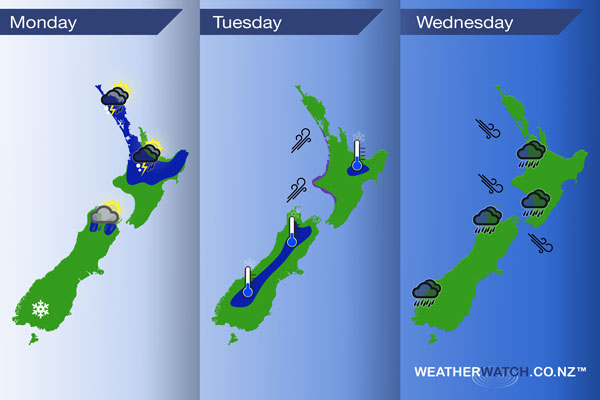
A cold southwesterly airflow lies over New Zealand today, unstable for some regions. Southwesterlies continue on Tuesday then northwesterlies develop on Wednesday with a front moving into western regions late afternoon / evening.
Monday
Blue – Showers about the upper North Island may be heavy with a risk of hail today, perhaps a chance of lightning / thunder also then easing late afternoon or evening.
A few isolated heavy showers with a chance of hail may spring up about the upper South Island this afternoon also, clearing in the evening.
A few snow flurries about the lower South Island to 500 or perhaps 400m at times.
Tuesday
Blue – A light frost to start the day for inland parts of the North and South Islands.
Purple – West to southwesterly winds are strong about western coastlines during the day.
Wednesday
Rain becoming heavy about some parts of the West Coast (South Island) from afternoon then easing later in the evening. Rain becomes heavy about the western North Island late afternoon / evening then easing overnight. Late afternoon or evening northwesterly winds are brisk to strong in the west and through Cook Strait.
– Please note, the idea behind this update is to focus on the main weather highlights, which is why not all regions are mentioned.
For specific 10 day information for your city, town, rural community or island please see the 1500 forecasts on our homepage!
– Aaron Wilkinson, WeatherWatch.co.nz
Comments
Before you add a new comment, take note this story was published on 11 Sep 2017.
Latest Video

VIDEO (NZ): Large low looms – who gets rain/wind & who does not
Another large low will bring severe weather to parts of both main islands of NZ this week, followed by a…
Related Articles
VIDEO (NZ): Large low looms – who gets rain/wind & who does not
Another large low will bring severe weather to parts of both main islands of NZ this week, followed by a…

VIDEO: Another big low late week brings severe weather risks to NZ
Severe weather is back in the forecast later this week after we kick off July with high pressure at the…

VIDEO: NZ 7 Day: One big low, a high, then another big low
Severe weather risks continue around NZ’s two main islands for the rest of Friday and going into Saturday, before conditions…


Add new comment