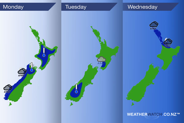
InfoGraphic: The Main Weather News Highlights across NZ: Mon, Tue, Wed
30/07/2017 8:17pm

> From the WeatherWatch archives
A northwesterly airflow increases over the South Island today ahead of a front which moves onto the lower South Island around midday then the upper South Island in the evening. A ridge for the North Island gradually weakens. A front lies across the lower North Island on Tuesday then another front moves onto the upper North Island from afternoon on Wednesday bringing in some heavy rain.
Monday
Blue – A frosty start for much of the inner North Island and upper South Island this morning. Meanwhile heavy rain about Fiordland this morning gradually pushes northwards during the day.
Tuesday
Blue – A touch frosty about the lower South Island inland, no major frosts. A front lies across the lower North Island during the day which may deliver some persistent rain to the Manawatu / Kapiti regions during the day.
Wednesday
Blue – As a front moves in from the Tasman Sea with it comes some heavy rain, pushing into Northland around midday then reaching the Bay Of Plenty overnight.
– Please note, the idea behind this update is to focus on the main weather highlights, which is why not all regions are mentioned.
For specific 10 day information for your city, town, rural community or island please see the 1500 forecasts on our homepage!
– Aaron Wilkinson, WeatherWatch.co.nz
Latest Video

Cold weekend, frosts return with high pressure, then a low late next week
The subantarctic airflow spreads over NZ today/tonight and into Saturday, dropping temperatures nationwide. Snow flurries are possible today to lower…
Related Articles
Cold weekend, frosts return with high pressure, then a low late next week
The subantarctic airflow spreads over NZ today/tonight and into Saturday, dropping temperatures nationwide. Snow flurries are possible today to lower…

Wintry burst of weather: Snow, squally showers then sunshine & frosts
A polar change (another one!) arrives on Friday for the South Island and goes nationwide on Saturday, leaving NZ under…

Antarctic southerly for parts of NZ Fri & Sat
For the first time this year a southerly from off Antarctica is heading towards the South Island, followed by more…

