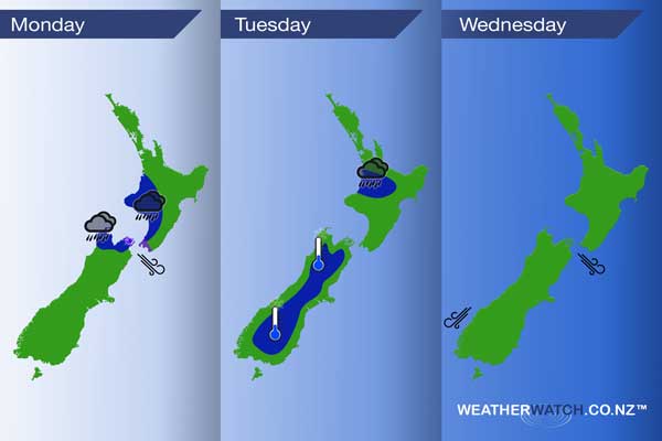
InfoGraphic: The Main Weather News Highlights across NZ: Mon, Tue, Wed
16/07/2017 7:00pm

> From the WeatherWatch archives
A front slowly moves northwards over the upper South Island today reaching the lower North Island late afternoon / evening. Gusty northwesterlies precede the front, changing southwest behind. This front weakens over the North Island on Tuesday, a ridge brings mainly settled weather further south. A northerly airflow increases on Wednesday.
Monday
Blue – Some rain about Tasman, the Marlborough Sounds and perhaps Nelson may be heavy at times, easing from afternoon. Late afternoon rain moves into Kapiti with heavy falls possible, moving a little further north in the evening.
Purple – Northwesterlies through the Cook Strait area are brisk / strong then easing this evening.
Tuesday
Blue – Rain about the upper North Island may be heavy early morning then easing away.
A frosty start for much of the inner South Island, generally no major frosts with 0 to -2 degrees most common. -4 isn’t out of the question in some isolated inland spots.
Wednesday
As a northerly quarter airflow increases over New Zealand during the day northwesterly winds becoming gusty through Cook Strait and northeasterlies strong about coastal Fiordland from afternoon.

– Please note, the idea behind this update is to focus on the main weather highlights, which is why not all regions are mentioned.
For specific 10 day information for your city, town, rural community or island please see the 1500 forecasts on our homepage!
– Aaron Wilkinson, WeatherWatch.co.nz
Comments
Before you add a new comment, take note this story was published on 16 Jul 2017.


Add new comment