InfoGraphic: The Main Weather News Highlights across NZ: Mon, Tue, Wed
18/06/2017 7:00pm

> From the WeatherWatch archives
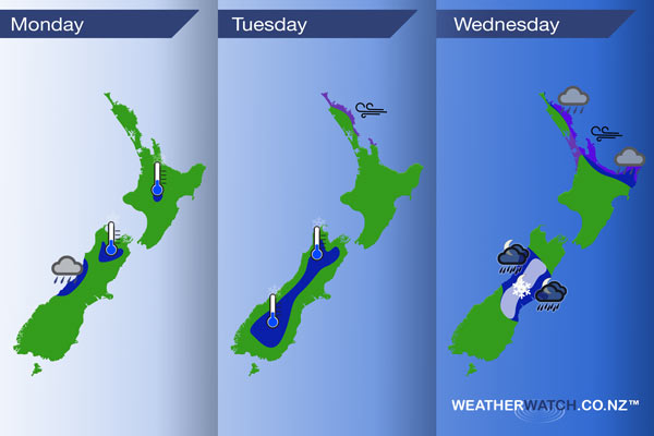
A front moves onto the lower South Island early this morning then moves northwards however it quickly weakens as it does so, meanwhile a large low brews in the north Tasman Sea. A high covers most of New Zealand on Tuesday, breezy easterlies for the far north. A front slowly moves southwards over the upper North Island on Wednesday, later in the day / overnight a front moves onto central parts of the South Island from the west.
Monday
Blue – There may be a few heavy showers early this morning for the West Coast then easing.
A light frost possible about the upper South Island inland and also about the Central North Island early this morning.
Tuesday
Blue – A frosty start about much of the inner South Island, no major frosts just standard in the range of 0 to -2 degrees celsius.
Purple – Easterly winds becoming breezy about eastern Northland from afternoon.
Wednesday
Blue – From late afternoon or evening heavy showers may start to affect eastern Northland then slowly slipping southwards through to East Cape overnight.
From evening rain with heavy falls may develop about the South Island’s West coast spreading eastwards overnight. Please note the front causing this rainfall may weaken in intensity during the next day or two on modeled outlooks.
White – As the front mentioned above crosses over the South Island there is a chance this may set up a warm advection snow event for the central South Island high country, cold air undercutting warmer air riding in above from the north. The situation is not set in stone and could change up over the next day or two but currently indications are snow with a chance of heavy falls may develop overnight to about 300m in South Canterbury and 600m about North Canterbury.
Purple – Easterly winds about Northland and Auckland are fairly gusty, moving southwards in the evening reaching East Cape overnight.
– Please note, the idea behind this update is to focus on the main weather highlights, which is why not all regions are mentioned.
For specific 10 day information for your city, town, rural community or island please see the 1500 forecasts on our homepage!
– Aaron Wilkinson, WeatherWatch.co.nz
Latest Video

Wintry weather coming: Snow, rain, wind & sunshine
A cold front is moving into NZ from Friday to Sunday with low pressure developing west of NZ and then…
Related Articles

Polar airflow + northern low = pockets of heavy rain & snow
A colder change is coming – and so too is a large low which will develop and grow over northern…
Wintry weather coming: Snow, rain, wind & sunshine
A cold front is moving into NZ from Friday to Sunday with low pressure developing west of NZ and then…

ClimateWatch: JULY outlook & what El Niño means for NZ
El Niño is officially here and still getting stronger in the months ahead, but it’s harder to notice its effects…

