InfoGraphic: The Main Weather News Highlights across NZ: Mon, Tue, Wed
21/05/2017 7:00pm

> From the WeatherWatch archives
An anticyclone brings mainly settled weather to New Zealand today, a front moves onto the lower South Island overnight. This front moves northwards over the South Island on Tuesday while northwesterlies develop in the north. Finally this front crosses onto the North Island on Wednesday however in a much more weakened state, a ridge starts to build over the South Island.
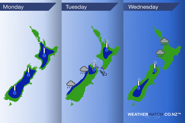
Monday
Blue – Frosts! That’s the main order of today, followed by a fair amount of sun. Watch for black ice especially about inland parts of the country this morning. -6 degrees celsius appears to be the coldest temperatures we are seeing first thing both about the Desert Road and near Twizel.
Tuesday
Blue – As a front pushes northwards along the West Coast of the South Island during the day there may be a few spots of heavy rain. Only a shower symbol this time round as yes while rain may be heavy at times, by West Coast standards it will be a fairly run of the mill situation.
Temperatures getting just into freezing territory for some inland areas, frosts may occur earlier in the night for the parts shaded in below especially in regards to the top of the South Island. As a west to northwesterly airflow builds it may mean dawn on Tuesday is actually a bit warmer then earlier in the night.
Purple – Northwesterly winds through Cook Strait are brisk to strong, easing later in the evening.
Wednesday
Blue – A ridge brings a cold start to inland parts of the South Island, not a severe frost but in the region of 0 to -2 degrees celsius for the areas shaded in blue below. Central Otago will likely see the coldest temperatures.
A decaying front brings showers to the western side of the North Island during the day between Taranaki and Auckland, also across into the Bay Of Plenty from afternoon.
– Please note, the idea behind this update is to focus on the main weather highlights, which is why not all regions are mentioned.
For specific 10 day information for your city, town, rural community or island please see the 1500 forecasts on our homepage!
– Aaron Wilkinson, WeatherWatch.co.nz
Latest Video

Cold weekend, frosts return with high pressure, then a low late next week
The subantarctic airflow spreads over NZ today/tonight and into Saturday, dropping temperatures nationwide. Snow flurries are possible today to lower…
Related Articles
Cold weekend, frosts return with high pressure, then a low late next week
The subantarctic airflow spreads over NZ today/tonight and into Saturday, dropping temperatures nationwide. Snow flurries are possible today to lower…

Wintry burst of weather: Snow, squally showers then sunshine & frosts
A polar change (another one!) arrives on Friday for the South Island and goes nationwide on Saturday, leaving NZ under…

Antarctic southerly for parts of NZ Fri & Sat
For the first time this year a southerly from off Antarctica is heading towards the South Island, followed by more…

