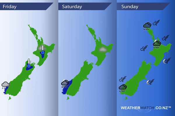
InfoGraphic: The Main Weather News Highlights across NZ: Fri, Sat, Sun
24/08/2017 7:00pm

> From the WeatherWatch archives
A north to northeasterly airflow lies over New Zealand today and on Saturday while a front lingers about the far south of the South Island.A northeasterly airflow increases on Sunday with a front rotating onto the upper North Island from afternoon.
Friday
Blue – Chance of a light frost for the upper South Island inland, also the Central North Island.
Showers about Fiordland may be heavy at times from late afternoon.
Chance patch of fog about northeastern parts of the North Island in the morning then breaking away.
Saturday
Blue – Rain heavy about Fiordland from evening.
A risk of fog for some northeastern parts of the North Island once again in the morning.
Sunday
Rain about Fiordland during the day may be heavy. As a front moves onto Northland late afternoon / evening expect some heavy rain which then moves southwards in the evening and overnight. Northeasterlies ahead of the front are looking to be quite brisk or strong at times, spreading to eastern parts of the country overnight.
– Please note, the idea behind this update is to focus on the main weather highlights, which is why not all regions are mentioned.
For specific 10 day information for your city, town, rural community or island please see the 1500 forecasts on our homepage!
– Aaron Wilkinson, WeatherWatch.co.nz
Latest Video

Slow go for northern low & southern cold
For the next few days low pressure will crawl over the upper North Island, driving in rain as far south…
Related Articles
Slow go for northern low & southern cold
For the next few days low pressure will crawl over the upper North Island, driving in rain as far south…

Slow moving low to track over northern NZ
A low pressure zone will slowly cross the North Island over the coming days, bringing hit and miss pockets of…

NI low pressure, SI polar change
Low pressure will move over the upper North Island this week, bringing hit and miss pockets of heavier rain into…

