
> From the WeatherWatch archives
A low pressure system moves through Central New Zealand tomorrow then the airflow turns southwesterly in it’s wake as it passes out to the east.
For the upper North Island expect showers to gradually ease and clear in the evening, northwesterly winds tend westerly in the afternoon. Northland may only see a few morning showers then expect sunny spells.
For the lower North Island expect showers, clearing for most in the evening also with northwesterlies tending westerly. Showers may be heavy with thunderstorms Taranaki southwards, not for the Wairarapa and perhaps southern Hawkes Bay till afternoon. The remainder of Hawkes Bay and Gisborne sees sunny spells and the odd shower passing over from the west during the day.
For the upper South Island expect a mix of cloud and showers, showers may be heavy with thunderstorms about the Nelson / Marlborough area then easing in the evening. The West Coast of the South Island may be fairly dry right on the coast however about the ranges isolated afternoon showers are possible then clearing later in the evening.
Canterbury may see rain, easing to a few showers in the afternoon which clear later in the evening.
Southland and Otago sees cloudy areas, the odd shower also especially afternoon / evening inland where there may be an isolated heavy fall and thunderstorm although a thunderstorm only has a low chance here.
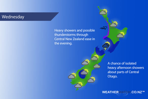
Not all regions and towns have been mentioned above. For specific 10 day information for your city, town, rural community or island please see the 1500 forecasts on our homepage!
– Aaron Wilkinson, WeatherWatch.co.nz
Latest Video

Cold weekend, frosts return with high pressure, then a low late next week
The subantarctic airflow spreads over NZ today/tonight and into Saturday, dropping temperatures nationwide. Snow flurries are possible today to lower…
Related Articles
Cold weekend, frosts return with high pressure, then a low late next week
The subantarctic airflow spreads over NZ today/tonight and into Saturday, dropping temperatures nationwide. Snow flurries are possible today to lower…

Wintry burst of weather: Snow, squally showers then sunshine & frosts
A polar change (another one!) arrives on Friday for the South Island and goes nationwide on Saturday, leaving NZ under…

Antarctic southerly for parts of NZ Fri & Sat
For the first time this year a southerly from off Antarctica is heading towards the South Island, followed by more…

