
> From the WeatherWatch archives
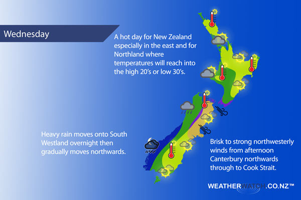
A strengthening northwesterly airflow lies over New Zealand on Wednesday as a front moves onto the lower South Island overnight.
For the upper North Island expect morning cloud to break to afternoon sun, some high cloud hangs around however. Winds from the west. Temperatures reaching the mid 20’s for many and even the high 20’s for some inland areas and Northland.
A mix of sun and cloud for the lower North Island in the west, winds from the northwest. A mainly sunny day for the east coast, a touch of high cloud at times. Temperatures getting into the early 30’s in the afternoon.
Cloudy for the West Coast of the South Island with showers, rain moves onto South Westland around midnight with heavy falls then pushing northwards. Mainly sunny along the east coast with thickening high cloud, northwesterly winds picking up in the afternoon especially Canterbury northwards where winds may be strong at times.
Brisk to strong northwesterlies develop through to Cook Strait area from afternoon.
Not all regions and towns have been mentioned above. For specific 10 day information for your city, town, rural community or island please see the 1500 forecasts on our homepage!
– Aaron Wilkinson, WeatherWatch.co.nz
Latest Video

Wintry weather coming: Snow, rain, wind & sunshine
A cold front is moving into NZ from Friday to Sunday with low pressure developing west of NZ and then…
Related Articles

Polar airflow + northern low = pockets of heavy rain & snow
A colder change is coming – and so too is a large low which will develop and grow over northern…
Wintry weather coming: Snow, rain, wind & sunshine
A cold front is moving into NZ from Friday to Sunday with low pressure developing west of NZ and then…

ClimateWatch: JULY outlook & what El Niño means for NZ
El Niño is officially here and still getting stronger in the months ahead, but it’s harder to notice its effects…

