
> From the WeatherWatch archives
An anticyclone muscles in over New Zealand on Thursday while a southeasterly airflow eases over the North Island.
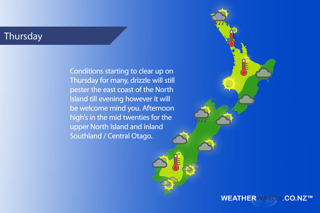
Mostly sunny weather for the upper North Island with dry or mainly dry conditions, could be a rogue shower about Northland. Light southerly quarter winds. Mostly sunny for the lower western North Island with southeasterly breezes, there may be some cloud and the chance of a shower spilling over from the east towards the ranges in the east.
Drizzle for the east coast, gradually becoming drier from afternoon then drizzle clears by evening. There may be some sun later in the day. Cool south to southeasterly winds. Any early showers clear Wellington then becoming mostly sunny. Southeasterly winds.
Any early light drizzle clears Nelson / Marlborough then cloud breaks to sunny spells, east to southeasterly winds. Chance of a morning drizzle patch for Canterbury then afternoon sunny spells break through, east to northeasterly winds becoming breezy.
A mix of sun and cloud along the West Coast, a few isolated showers are possible in the afternoon, for North Westland especially. Light winds tend northwest in the afternoon. Sunny areas and some high cloud about Southland and Otago, light winds. East to northeasterly winds freshen about the Otago coast.
Blue – Heavy form of precipitation – or – low temperatures, typically below 1 to 2 degrees celsius.
White – Snow
Purple – Strong winds.
Yellow – Temperatures around the mid 20 degree mark or over.
Not all regions and towns have been mentioned above. For specific 10 day information for your city, town, rural community or island please see the 1500 forecasts on our homepage!
– Aaron Wilkinson, WeatherWatch.co.nz
Latest Video

Cold weekend, frosts return with high pressure, then a low late next week
The subantarctic airflow spreads over NZ today/tonight and into Saturday, dropping temperatures nationwide. Snow flurries are possible today to lower…
Related Articles
Cold weekend, frosts return with high pressure, then a low late next week
The subantarctic airflow spreads over NZ today/tonight and into Saturday, dropping temperatures nationwide. Snow flurries are possible today to lower…

Wintry burst of weather: Snow, squally showers then sunshine & frosts
A polar change (another one!) arrives on Friday for the South Island and goes nationwide on Saturday, leaving NZ under…

Antarctic southerly for parts of NZ Fri & Sat
For the first time this year a southerly from off Antarctica is heading towards the South Island, followed by more…

