
> From the WeatherWatch archives
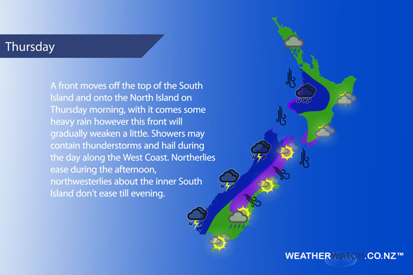
A front moves over the North Island from Thursday morning then pushes northwards, it will gradually weaken. Front pre frontal northerlies ease from afternoon. Northwesterlies over the South Island ease later in the day.
Mostly cloudy for the upper North Island, a few showers from afternoon then some evening rain. The Waikato sees a few showers develop in the morning, a period of afternoon rain (possibly heavy) then easing in the evening. Northwesterly winds.
Rain develops in the morning about the lower western North Island (heavy falls about Taranaki ease during the afternoon) then clearing in the evening, gusty northwesterly winds (gale about Taranaki easing later in the day).
Thick high cloud along the east coast, a few spots of rain may spread from the west in the afternoon then clearing in the evening. Brisk northwesterly winds ease overnight. Morning rain for Wellington then sunny spells break through from afternoon, gale northerly winds ease from afternoon.
Morning rain about Nelson and Marlborough, possibly heavy then clearing. A shower or two may linger about Nelson through till evening. Becoming mostly sunny in the afternoon otherwise. Strong to gale northwest winds gradually ease from afternoon.
Morning spots of rain for Canterbury then becoming mostly sunny, early heavy falls about the high country eases to showers. Showers may still be heavy at times with a risk of thunder spreading from the west about the high country. Gusty northwesterlies with gales about North Canterbury, easing later in the day.
Early heavy rain and possible thunderstorms along the West Coast ease to showers, showers may still flare up now and then with a risk of further heavy falls / thunderstorms and hail then easing later in the evening. Breezy northwesterlies ease later on.
Any early morning rain clears Southland and Otago then mostly sunny with some high cloud, late afternoon / evening brings the risk of isolated showers about Otago. Northwesterly winds.
Blue – Heavy form of precipitation or cold temperatures, typically below 1 to 2 degrees celsius.
White – Snow
Purple – Strong winds.
Yellow – Temperatures around the mid 20 degree mark or over.
Not all regions and towns have been mentioned above. For specific 10 day information for your city, town, rural community or island please see the 1500 forecasts on our homepage!
– Aaron Wilkinson, WeatherWatch.co.nz
Latest Video

Cold weekend, frosts return with high pressure, then a low late next week
The subantarctic airflow spreads over NZ today/tonight and into Saturday, dropping temperatures nationwide. Snow flurries are possible today to lower…
Related Articles
Cold weekend, frosts return with high pressure, then a low late next week
The subantarctic airflow spreads over NZ today/tonight and into Saturday, dropping temperatures nationwide. Snow flurries are possible today to lower…

Wintry burst of weather: Snow, squally showers then sunshine & frosts
A polar change (another one!) arrives on Friday for the South Island and goes nationwide on Saturday, leaving NZ under…

Antarctic southerly for parts of NZ Fri & Sat
For the first time this year a southerly from off Antarctica is heading towards the South Island, followed by more…

