
> From the WeatherWatch archives
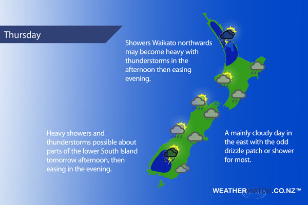
A humid northeasterly airflow covers most of New Zealand tomorrow bringing cloudy skies in the east with the odd drizzle patch. Some sun possible out west however afternoon thunderstorms possible also.
For the upper North Island expect the odd shower (Northland may be mainly dry in the morning however) then in the afternoon showers becoming heavy with possible thunderstorms. Showers may also become heavy about the Bay Of Plenty, Central North Island and Taranaki however the thunderstorm risk is less.
Mainly cloudy for Wellington and along the east coast, showers or drizzle patches in the east.
The South Island is mainly cloudy in the east, the odd drizzle patch about. Sunny spells elsewhere with isolated showers possible in the afternoon. Parts of Southland / Otago and about the ranges of Fiordland these showers may become heavy with thunderstorms then easing in the evening.
Not all regions and towns have been mentioned above. For specific 10 day information for your city, town, rural community or island please see the 1000’s of forecasts on our homepage!
– Aaron Wilkinson, WeatherWatch.co.nz
Latest Video

Matariki, the long weekend + the outlook for next week
Wet weather and cloud continues along the eastern side of the country with the heaviest rain now moving into northern…
Related Articles
Matariki, the long weekend + the outlook for next week
Wet weather and cloud continues along the eastern side of the country with the heaviest rain now moving into northern…

More eastern rain, but a drier long weekend coming
Rain continues today along the eastern South Island and lower North Island, coming in from the east with heavy falls….

More heavy rain, snow – but large dry areas, especially as we go into the long weekend
Heavy rain will continue for parts of Canterbury and Marlborough over the next day or two and it will gradually…

