
> From the WeatherWatch archives
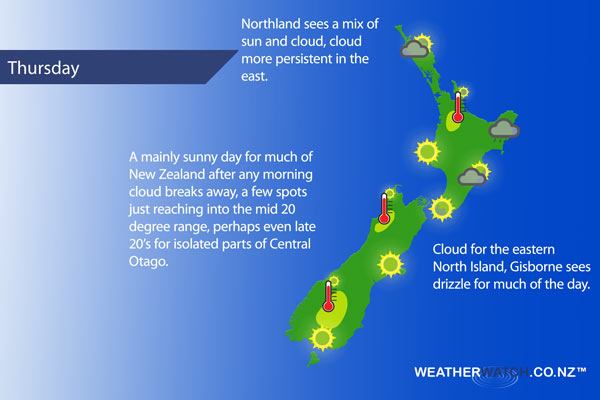
A large high covers most of New Zealand on Thursday, a southeasterly airflow for the upper North Island eases during the day.
A mainly sunny day for the upper North Island, just some cloud about Northland at times especially in the east where there is even the low risk of a shower or two brushing the coastline. Temperatures may just crack into the mid 20 degree celsius range about parts of inland Waikato.
The lower North Island is sunny in the west from Wellington through to Taranaki. The Wairarapa sees any morning cloud break to mostly sunny weather, Any early drizzle about Hawkes Bay clears then cloud breaks to some sun in the afternoon. Gisborne sees drizzle for much of the day, not clearing till later in the evening.
A mainly sunny day for much of the South Island, perhaps a touch of early cloud otherwise it’s looking to be a good one. High’s reaching into the mid 20’s for some inland areas, perhaps even an outside chance of late 20 degree temperatures for some parts of Central Otago.
Blue – Heavy form of precipitation.
Purple – Strong winds.
Yellow – Temperatures around the mid 20 degree mark or over.
Not all regions and towns have been mentioned above. For specific 10 day information for your city, town, rural community or island please see the 1500 forecasts on our homepage!
– Aaron Wilkinson, WeatherWatch.co.nz
Latest Video

Cold weekend, frosts return with high pressure, then a low late next week
The subantarctic airflow spreads over NZ today/tonight and into Saturday, dropping temperatures nationwide. Snow flurries are possible today to lower…
Related Articles
Cold weekend, frosts return with high pressure, then a low late next week
The subantarctic airflow spreads over NZ today/tonight and into Saturday, dropping temperatures nationwide. Snow flurries are possible today to lower…

Wintry burst of weather: Snow, squally showers then sunshine & frosts
A polar change (another one!) arrives on Friday for the South Island and goes nationwide on Saturday, leaving NZ under…

Antarctic southerly for parts of NZ Fri & Sat
For the first time this year a southerly from off Antarctica is heading towards the South Island, followed by more…

