
> From the WeatherWatch archives
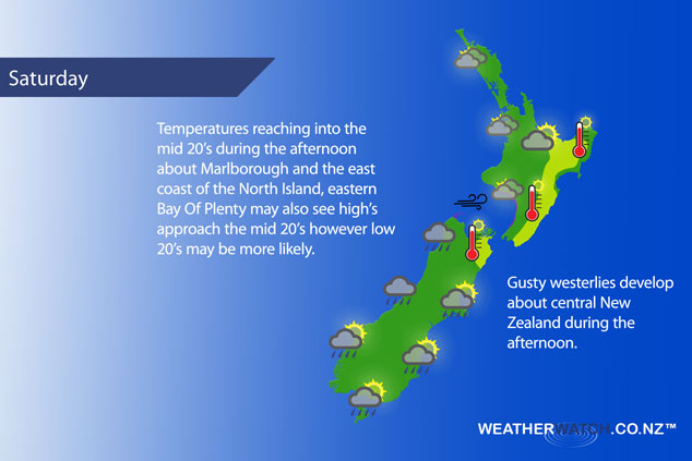
A front pushes northwards over the South Island during Saturday reaching the lower North Island in the evening, winds from the northwest ahead of this front then changing southwest in behind.
Mostly cloudy for the upper North Island with any early showers clearing away then the chance of a shower again from afternoon. Showers more likely later in the evening as a front moves in, breezy westerly winds. Warmest afternoon temperatures about eastern Bay Of Plenty where morning cloud breaks to mainly sunny weather.
Sunny areas and increasing cloud for most about the lower western North Island however Taranaki is mostly cloudy from morning, showers late afternoon and evening. Freshening west to northwesterly winds. Mostly sunny with high cloud developing from afternoon along the east coast, light winds and warm temperatures. A coastal sea breeze may develop about Hawkes Bay and Gisborne. Mostly cloudy for Wellington with a few showers late afternoon and evening. Breezy northwesterly winds.
Sunny areas and some high cloud about Nelson and Marlborough, northwesterlies pick up in the afternoon then in the evening winds change southwest although remaining mainly dry. A few showers about the northwest Nelson area from afternoon then clearing in the evening. Sunny areas and increasing high cloud in Canterbury, an afternoon southwest change may bring a shower or two then clearing in the evening.
Rain spreads northwards along the West Coast during the day, reaching North Westland late morning then easing from the south as northwesterlies change southwest. There may be some sun break through for a time in the evening (more so about South Westland) then overnight further rain moves into Fiordland.
Morning rain eases and clears about Southland and Otago then sunny spells break through, later in the evening showers move into Southland then overnight into Otago. West to southwesterly winds, freshening from afternoon about coastal Southland.
Blue – Heavy form of precipitation – or – low temperatures, typically below 1 to 2 degrees celsius.
White – Snow
Purple – Strong winds.
Yellow – Temperatures around the mid 20 degree mark or over.
Not all regions and towns have been mentioned above. For specific 10 day information for your city, town, rural community or island please see the 1500 forecasts on our homepage!
– Aaron Wilkinson, WeatherWatch.co.nz
Latest Video

Slow go for northern low & southern cold
For the next few days low pressure will crawl over the upper North Island, driving in rain as far south…
Related Articles
Slow go for northern low & southern cold
For the next few days low pressure will crawl over the upper North Island, driving in rain as far south…

Slow moving low to track over northern NZ
A low pressure zone will slowly cross the North Island over the coming days, bringing hit and miss pockets of…

NI low pressure, SI polar change
Low pressure will move over the upper North Island this week, bringing hit and miss pockets of heavier rain into…

