
> From the WeatherWatch archives
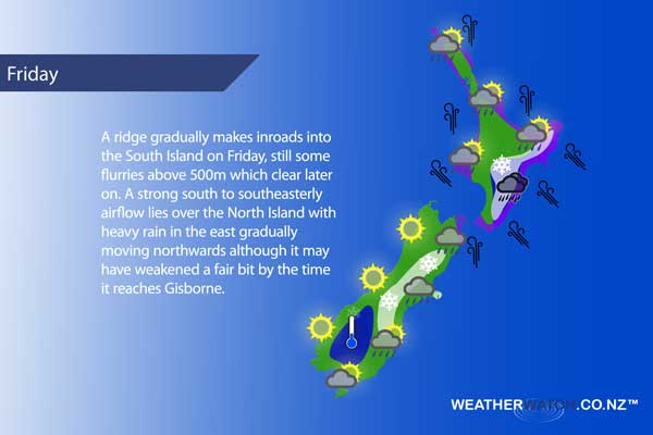
Friday sees a ridge slowly make some headway over the South Island while strong south to southeasterly winds ease later in the day over the North Island.
For the upper North Island expect cloudy areas, a few showers push through in the afternoon. Showers more likely out west about Auckland, Northland may see more widespread showers, still more persistent in the west. The Waikato and Bay Of Plenty only see a chance of showers in the afternoon otherwise mainly dry. Gusty southerlies, strong to gale for a time along western coastlines from afternoon then easing later in the evening.
About the lower North Island in the west, morning rain with heavy falls, especially the further east one goes then easing from afternoon to showers. Snow to 700 or perhaps 600m. Gusty southeasterly winds, strong to gale force about the coast then easing from evening.
Heavy rain for the eastern North Island, easing in the evening. Snow sitting above 800m for Hawkes Bay / Gisborne, above 600m for the Wairarapa. Gusty south to southeasterly winds. The odd shower for Wellington with a few snow flurries above 600m, strong southerlies (gale force at times in the morning especially through Cook Strait) ease later in the day.
Mostly cloudy about Marlborough and Nelson, chance of a shower otherwise mainly dry. Cloud breaks in the afternoon to some sun about Nelson, later in the day for Marlborough. Strong southeasterly winds (gale about the Marlborough coast) ease later in the day then die out overnight.
Showers and snow flurries to 500m about Canterbury ease becoming few and far between then clearing later in the evening. South to southwesterly winds die away at night. Heavy frosts overnight inland. Mainly sunny along the West Coast with south to southeasterly winds.
A mainly sunny day about Southland and inland Otago after any morning cloud clears. Any early showers clear about coastal Otago then sunny spells develop in the afternoon. Light east to northeasterly winds, southerlies in the morning for coastal Otago. Heavy frosts develop overnight.
Blue – Heavy form of precipitation or cold temperatures, typically below 1 to 2 degrees celsius.
White – Snow
Purple – Strong winds.
Yellow – Temperatures around the mid 20 degree mark or over.
Not all regions and towns have been mentioned above. For specific 10 day information for your city, town, rural community or island please see the 1500 forecasts on our homepage!
– Aaron Wilkinson, WeatherWatch.co.nz
Latest Video

Cold weekend, frosts return with high pressure, then a low late next week
The subantarctic airflow spreads over NZ today/tonight and into Saturday, dropping temperatures nationwide. Snow flurries are possible today to lower…
Related Articles
Cold weekend, frosts return with high pressure, then a low late next week
The subantarctic airflow spreads over NZ today/tonight and into Saturday, dropping temperatures nationwide. Snow flurries are possible today to lower…

Wintry burst of weather: Snow, squally showers then sunshine & frosts
A polar change (another one!) arrives on Friday for the South Island and goes nationwide on Saturday, leaving NZ under…

Antarctic southerly for parts of NZ Fri & Sat
For the first time this year a southerly from off Antarctica is heading towards the South Island, followed by more…

