InfoGraphic: The Big Picture for Wednesday / Thursday
12/11/2019 6:00pm

> From the WeatherWatch archives
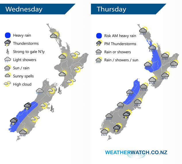
A northerly airflow lies over New Zealand today, becoming strong over the South Island. A cold front moves onto the lower South Island from afternoon moving northwards to reach the lower North Island overnight. This front moves off the North Island away to the northeast on Thursday afternoon meanwhile an area of low pressure moves onto the South Island bringing potentially unstable conditions.
A mix of sun and cloud for the western North Island today, cloud thicker about Taranaki and Kapiti during the day with the chance of a light shower or two. Rain moves into the southwestern North Island overnight. Mostly sunny with a touch of high cloud for the east coast. Cloudy for the West Coast of the South Island, rain about South Westland with heavy falls and possible thunderstorms gradually pushes northwards during the day. Expect plenty of high cloud in the east. Rain moves into Southland this afternoon then Otago in the evening with a west to southwest change.
Morning rain with a chance of heavy falls in the west for the North Island on Thursday then clearing with sunny areas developing, later in the evening showers move back in again. Morning high cloud along the east coast with some rain spreading from the west at times then becoming mostly sunny in the afternoon. Early morning heavy rain eases about North Westland to showers, showers elsewhere along the West Coast then rain moves in again during the afternoon. The east coast is largely dry although the odd shower is possible, morning showers about Canterbury then clearing away. During the afternoon showers become heavy with a risk of thunder / hail from Southland through to South Canterbury in the east then clearing at night.
By Weather Analyst Aaron Wilkinson – WeatherWatch.co.nz
Latest Video

NZ: 8 Day outlook as gales & rain ease, high pressure builds
Damaging wind gusts and heavy rain will continue to affect some parts of the North Island and brushing Marlborough today…
Related Articles
NZ: 8 Day outlook as gales & rain ease, high pressure builds
Damaging wind gusts and heavy rain will continue to affect some parts of the North Island and brushing Marlborough today…

Pockets of hit & miss heavy rain, snow moves northwards
Low pressure continues to slowly move across the upper North Island and for some that will bring the sun out,…

Slow go for northern low & southern cold
For the next few days low pressure will crawl over the upper North Island, driving in rain as far south…

