InfoGraphic: The Big Picture for Wednesday / Thursday
22/10/2019 7:15pm

> From the WeatherWatch archives
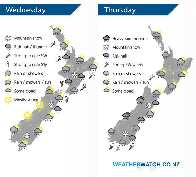
A strong southerly quarter change moves over the North Island today, conditions gradually ease further south. Overnight a cold southwest change moves onto the lower South Island, this change pushes northwards moving onto the lower North Island midday Thursday.
Heavy rain or showers for most North Island regions this morning, hail / thunder possible also. Conditions easing in the west from afternoon then along the east coast in the evening. Expect strong to gale southwesterly winds for some coastal areas especially Northland and Auckland then easing by evening. Some snow about hills and ranges of the lower North Island down to 500m. A sunny day for the West Coast of the South Island and Nelson, early heavy showers and snow to 500m about Marlborough clears then afternoon sun breaks through. Heavy rain or showers about Canterbury north of the Rakaia River with a risk of hail then easing, sunnier further south. Some snow about Canterbury to 300m before clearing. Morning showers and snow flurries to 300m about Southland and Otago clear then sun breaks through, later in the evening or overnight rain moves in with a gusty SW change.
Conditions are dry to start about the western North Island on Thursday, rain or showers moves into the southwestern corner during the morning then further north around midday. Sunny areas and some high cloud in the east, some rain develops about Wairarapa in the afternoon then a few showers may make it into Hawkes Bay in the evening with a southwest change. Heavy morning rain for the West Coast of the South Island then easing. Dry to start about Canterbury then a fresh southwest change pushes northwards during the morning bringing showers, some may be heavy with a risk of hail. Some snow develops about the ranges of North Canterbury down to 500-600m. Rain or showers may be heavy in the morning about the far south with a risk of hail then easing, fresh cold southwesterlies and snow to 400m in the morning then gradually lifting.
By Weather Analyst Aaron Wilkinson – WeatherWatch.co.nz
Latest Video

Cold weekend, frosts return with high pressure, then a low late next week
The subantarctic airflow spreads over NZ today/tonight and into Saturday, dropping temperatures nationwide. Snow flurries are possible today to lower…
Related Articles
Cold weekend, frosts return with high pressure, then a low late next week
The subantarctic airflow spreads over NZ today/tonight and into Saturday, dropping temperatures nationwide. Snow flurries are possible today to lower…

Wintry burst of weather: Snow, squally showers then sunshine & frosts
A polar change (another one!) arrives on Friday for the South Island and goes nationwide on Saturday, leaving NZ under…

Antarctic southerly for parts of NZ Fri & Sat
For the first time this year a southerly from off Antarctica is heading towards the South Island, followed by more…

