InfoGraphic: The Big Picture for Wednesday / Thursday
17/09/2019 7:00pm

> From the WeatherWatch archives
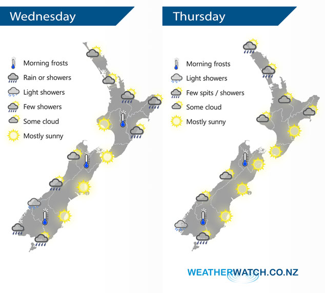
An anticyclone moves over most of New Zealand today coming in from the Tasman Sea, this high sticks around tomorrow bringing mainly settled weather.
Most of the North Island is fairly settled today, however expect a few morning showers in the east to clear then afternoon sun breaks through, showers may linger about Gisborne till evening. The Bay Of Plenty sees a few light showers develop this afternoon. For the South Island, expect a few showers about South Westland, a shower or two makes it a little further northwards at times and into Southland now and then. Mostly sunny conditions elsewhere.
Expect a mix of sun and cloud for most upper North Island regions on Thursday, a few showers are possible also especially north of Auckland. The lower North Island has mostly sunny conditions. Mostly sunny for the east and north of the South Island, some cloud at times in the west. A shower or spit moves into Fiordland and perhaps Southland at times.
By Weather Analyst Aaron Wilkinson – WeatherWatch.co.nz
Latest Video

Cold fronts continue, wind & rain for some Fri/Sat
Wet weather is moving over the North Island today, while the South Island has drier skies – ahead of another…
Related Articles
Cold fronts continue, wind & rain for some Fri/Sat
Wet weather is moving over the North Island today, while the South Island has drier skies – ahead of another…

Cold fronts vs high pressure
A cold front is moving up NZ today and into Tuesday, but will fall apart as it heads north and…

Wintry change coming for SI and lower NI
Some wet weather, along with a drop in temperatures, will move into the lower South Island later on Sunday and…

