InfoGraphic: The Big Picture for Wednesday / Thursday
6/03/2018 6:00pm

> From the WeatherWatch archives
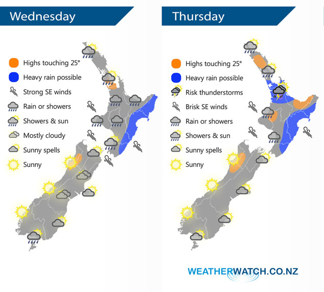
A low and combined southeasterly airflow brings unsettled weather to the North Island today and on Thursday, calmer for the South Island although areas of cloud persist in the east at times.
A fairly unsettled day for most of the North Island today with areas of rain, heavy falls look most likely to occur along the east coast however there is a chance rain could be heavy at times in the west especially this morning Taranaki southwards then in the afternoon Taranaki northwards. There may be some thunderstorm activity also, this morning in the west and then some other regions about the upper North Island in the afternoon.
A mostly cloudy day for Nelson and Marlborough, Marlborough sees a few showers with rain for the Sounds. Mostly cloudy about Canterbury with the chance of a light shower or drizzle patch about inland areas for much of the day, some sun breaks through in the afternoon near the coast. A mostly sunny morning for the far south then a small southwest flick brings a light shower or two to Southland from afternoon then Otago late afternoon or evening. A mainly sunny day for the West Coast with some high cloud in the north.
A mix of showers, heavy rain and possible thunderstorms for the North Island on Thursday. Southeasterly winds will be strong about southwestern regions especially near the coast. The South Island is a bit calmer however areas of cloud still hang around along the east coast, sunny for the West Coast.
By Weather Analyst Aaron Wilkinson – WeatherWatch.co.nz
Latest Video

Tracking the showers & a potential wintry blast late next week
NZ is on the edge of high pressure with anticyclones moving through at times over the next several days bringing…
Related Articles
Tracking the showers & a potential wintry blast late next week
NZ is on the edge of high pressure with anticyclones moving through at times over the next several days bringing…

Some polar airflows but more high pressure to affect NZ’s weather
Showers are in the forecast over the next several days, we track where and when they occur – but there…

Tracking the showers & colder changes
High pressure isn’t over NZ, but is nearby – and it’s affecting our airflows and who gets wet weather and…

