InfoGraphic: The Big Picture for Wednesday / Thursday
4/06/2019 7:00pm

> From the WeatherWatch archives
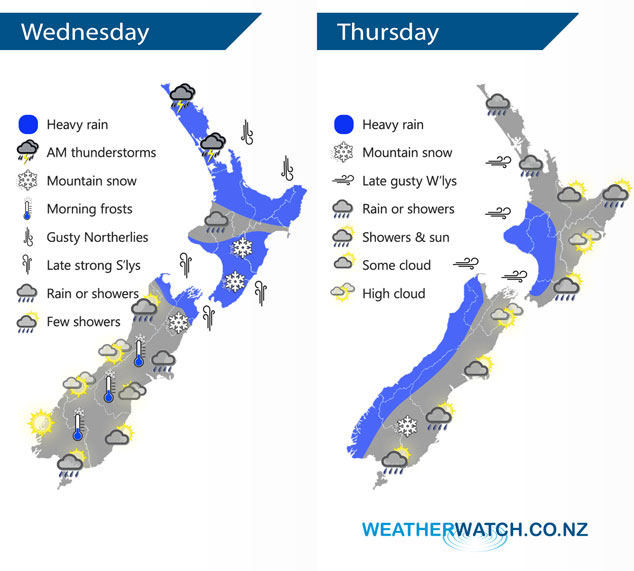
A reasonably deep low pressure system moves over the North Island and upper South Island on Wednesday bringing unsettled weather, a ridge of high pressure brings more settled conditions further south. A cold front pushes northwards over the South Island during Thursday, reaching the lower North Island in the evening.
Wednesday sees rain for the upper North Island in the morning with heavy falls and possible thunderstorms, finally easing about Bay Of Plenty late afternoon. The odd shower about the lower North Island then SSE winds strengthen from afternoon bringing rain with heavy falls which gradually pushes northwards in the evening. Overnight snow in the ranges about the lower North Island to 700m. Fairly cloudy for the upper South Island with some rain or showers about Nelson / Marlborough then clearing overnight. Snow may fall in the ranges behind Kaikoura / Marlborough down to 600 or perhaps 500m before clearing overnight. The lower South Island is a bit more settled with some high cloud in the west, cloudy areas in the east with a few showers for Southland.
Heavy rain spreads fairly promptly along western New Zealand on Thursday reaching the lower western North Island in the evening, rain could contain hail and thunderstorms. Westerlies becoming strong about the western North Island from afternoon. The odd shower for Northland and Auckland then overnight heavy showers. Mostly sunny in the east, any early rain clears Gisborne, spots of rain possible about Wairarapa in the evening. Scattered morning rain for Southland and Otago then showers push northwards late afternoon and evening, possibly heavy with some hail. Snow to 500m about the lower South Island in the evening.
By Weather Analyst Aaron Wilkinson – WeatherWatch.co.nz
Latest Video

Cold weekend, frosts return with high pressure, then a low late next week
The subantarctic airflow spreads over NZ today/tonight and into Saturday, dropping temperatures nationwide. Snow flurries are possible today to lower…
Related Articles
Cold weekend, frosts return with high pressure, then a low late next week
The subantarctic airflow spreads over NZ today/tonight and into Saturday, dropping temperatures nationwide. Snow flurries are possible today to lower…

Wintry burst of weather: Snow, squally showers then sunshine & frosts
A polar change (another one!) arrives on Friday for the South Island and goes nationwide on Saturday, leaving NZ under…

Antarctic southerly for parts of NZ Fri & Sat
For the first time this year a southerly from off Antarctica is heading towards the South Island, followed by more…

