InfoGraphic: The Big Picture for Wednesday / Thursday
7/05/2019 7:00pm

> From the WeatherWatch archives
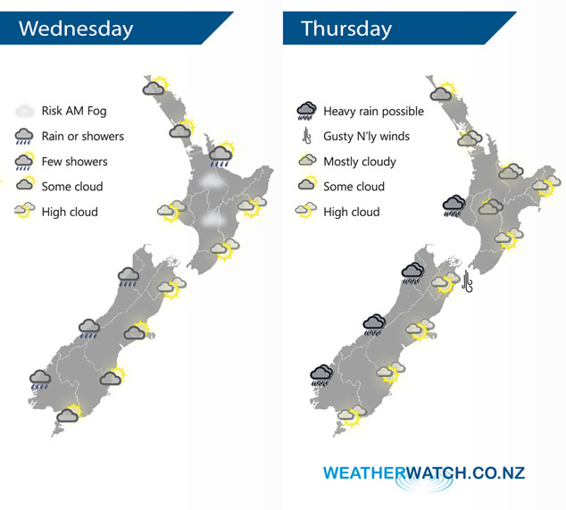
A northerly airflow lies over New Zealand today ahead of a front which slowly makes it’s way onto the western side of the South Island. A large high gets shunted to the east. Northerlies continue on Thursday, tending northwest later in the day as yet another front moves in.
A mix of sun and cloud for much of the North Island today, some morning fog possible for inland areas. A light shower or two may affect Northland, Bay Of Plenty and perhaps extending into the Waikato at times. Rain or showers about South Westland pushes into North Westland during the afternoon, morning mid level cloud breaks to sunny areas and high cloud out east. A few spots of rain about Southland and Otago in the afternoon then Canterbury in the evening.
Dry for most of the North Island on Thursday then some rain moves into Taranaki from afternoon, possibly becoming heavy in the evening. Dry out east with high cloud, northerlies gusty through Cook Strait. Rain for the South Island’s West Coast may be heavy at times, more so from afternoon. Mainly dry in the east with some high cloud, a small area of low pressure may form about Otago bringing the chance of showers late afternoon / evening.
By Weather Analyst Aaron Wilkinson – WeatherWatch.co.nz
Latest Video

Cold weekend, frosts return with high pressure, then a low late next week
The subantarctic airflow spreads over NZ today/tonight and into Saturday, dropping temperatures nationwide. Snow flurries are possible today to lower…
Related Articles
Cold weekend, frosts return with high pressure, then a low late next week
The subantarctic airflow spreads over NZ today/tonight and into Saturday, dropping temperatures nationwide. Snow flurries are possible today to lower…

Wintry burst of weather: Snow, squally showers then sunshine & frosts
A polar change (another one!) arrives on Friday for the South Island and goes nationwide on Saturday, leaving NZ under…

Antarctic southerly for parts of NZ Fri & Sat
For the first time this year a southerly from off Antarctica is heading towards the South Island, followed by more…

