InfoGraphic: The Big Picture for Wednesday / Thursday
9/04/2019 7:34pm

> From the WeatherWatch archives
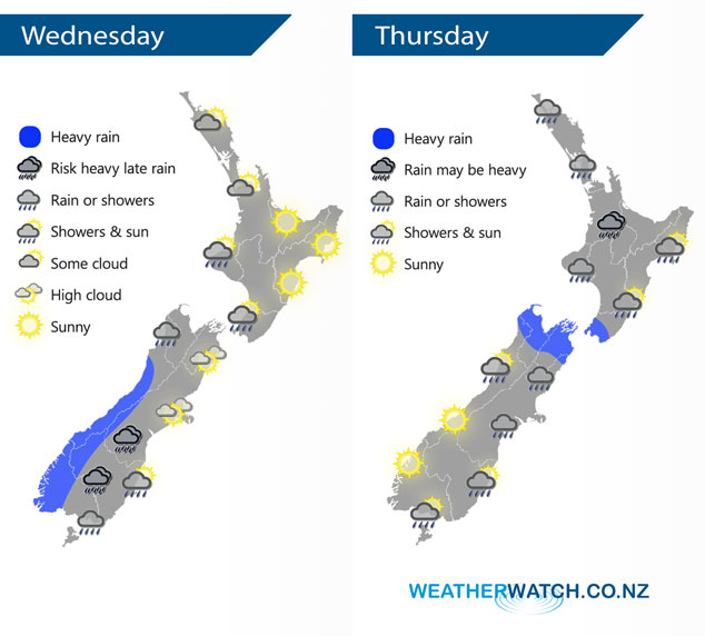
A cold front slowly pushes northwards over the South Island today, northwesterlies ahead of this front then changing southwest in behind. A ridge of high pressure slowly loses its grip further north. This front moves off the upper South Island on Thursday then onto the North Island, meanwhile a ridge moves over the South Island.
A mix of sun and cloud for the upper North Island today, sunny skies in the east (Gisborne to Wairarapa). Cloudy periods from Taranaki through to Kapiti, may be a shower or two at times also. Rain for the South Islands West Coast, heavy about South Westland with heavy falls and a chance of thunderstorms, heavy falls push northwards in the evening. Rain moves into the lower South Island this morning with a southwest change, pushing into South Canterbury this evening.
Rain pushing into the western North Island late Thursday morning, rain may be heavy for a time about the likes of Waikato in the afternoon then easing evening. Dry in the east then some rain starts to push in from the west during the afternoon and evening. Heavy rain about Nelson / Marlborough eases late afternoon, showers about Canterbury slowly ease and clear. A few morning showers about Southland and Otago then some sun, further showers possible later in the day.
By Weather Analyst Aaron Wilkinson – WeatherWatch.co.nz
Latest Video

Cold weekend, frosts return with high pressure, then a low late next week
The subantarctic airflow spreads over NZ today/tonight and into Saturday, dropping temperatures nationwide. Snow flurries are possible today to lower…
Related Articles
Cold weekend, frosts return with high pressure, then a low late next week
The subantarctic airflow spreads over NZ today/tonight and into Saturday, dropping temperatures nationwide. Snow flurries are possible today to lower…

Wintry burst of weather: Snow, squally showers then sunshine & frosts
A polar change (another one!) arrives on Friday for the South Island and goes nationwide on Saturday, leaving NZ under…

Antarctic southerly for parts of NZ Fri & Sat
For the first time this year a southerly from off Antarctica is heading towards the South Island, followed by more…

