InfoGraphic: The Big Picture for Wednesday / Thursday
29/01/2019 6:00pm

> From the WeatherWatch archives
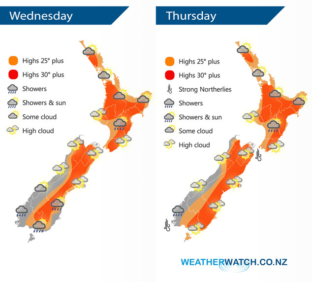
A large anticyclone covers New Zealand today bringing mainly settled and hot weather. This anticyclone starts to shunt eastwards on Thursday letting in a north to northwesterly airflow over the South Island.
Another hot one today, for the North Island most regions see some sun and high cloud, watch for a few areas of morning cloud also especially in the northeast. As indicated in the map below there is the chance of a late afternoon / evening shower for inland parts of the lower North Island, if any occur these will be fairly isolated and likely affect only a small area. Sunny areas and some high cloud for the South Island, a few spots of rain may affect Southland and Otago at times. Some patchy rain or showers about Fiordland is likely, especially morning then dry spells develop from afternoon.
Mostly sunny for the North Island on Thursday, some morning cloud possible once again mainly in the northeast. Risk of an isolated shower late afternoon / evening about inland parts of the lower North Island otherwise mainly dry. Mostly sunny for the South Island with areas of high cloud, cloud gradually thickens about Fiordland with a few showers there later in the evening.
By Weather Analyst Aaron Wilkinson – WeatherWatch.co.nz
Latest Video

Cold weekend, frosts return with high pressure, then a low late next week
The subantarctic airflow spreads over NZ today/tonight and into Saturday, dropping temperatures nationwide. Snow flurries are possible today to lower…
Related Articles
Cold weekend, frosts return with high pressure, then a low late next week
The subantarctic airflow spreads over NZ today/tonight and into Saturday, dropping temperatures nationwide. Snow flurries are possible today to lower…

Wintry burst of weather: Snow, squally showers then sunshine & frosts
A polar change (another one!) arrives on Friday for the South Island and goes nationwide on Saturday, leaving NZ under…

Antarctic southerly for parts of NZ Fri & Sat
For the first time this year a southerly from off Antarctica is heading towards the South Island, followed by more…

