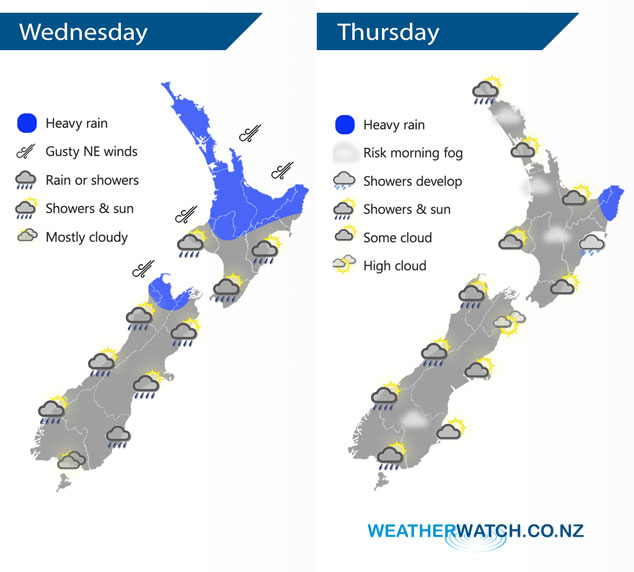
InfoGraphic: The Big Picture for Wednesday / Thursday
28/08/2018 7:00pm

> From the WeatherWatch archives
A low sits in the Tasman Sea today with an occluded front stretching out from this low passing over New Zealand from west to east during the day. Low pressure covers New Zealand on Thursday with a centre off to the west of the country in the Tasman Sea and another off to the northeast of the North Island.
Rain for the upper North Island is heavy at times today, slowly easing from the west late afternoon onwards. Not easing about the Bay Of Plenty till overnight. Morning rain for the lower North Island then easing to showers, some sun possible from afternoon especially about the Wairarapa. Rain for the West Coast of the South Island eases to showers around midday, rain about Nelson and Marlborough with a chance of heavy falls clearing early afternoon with areas of sun breaking through. Some morning rain for the east coast then sunny areas develop in the afternoon.
Fairly dry for most of the North Island on Thursday however there may be some heavy rain about Gisborne / East Cape then easing in the evening. The odd shower moves into Northland in the evening. There may also be areas of low cloud or fog to start the day. For the South Island, in the west morning showers clear then sunny areas develop. In the east expect a mix of sun and cloud, light winds tend to the south in the afternoon.

By Weather Analyst Aaron Wilkinson – WeatherWatch.co.nz
Comments
Before you add a new comment, take note this story was published on 28 Aug 2018.


Add new comment