InfoGraphic: The Big Picture for Wednesday / Thursday
14/08/2018 7:00pm

> From the WeatherWatch archives
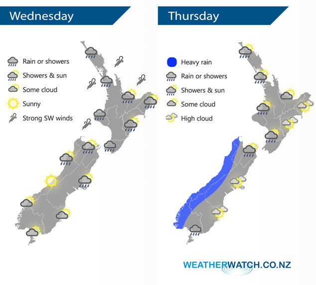
A weak ridge of high pressure moves onto the South Island this morning, southwesterlies ease later in the day elsewhere. A northwesterly airflow lies over New Zealand on Thursday.
A showery day for much of the North Island today with fresh cool southwesterly winds, long dry spells develop by evening. Showers clear for the upper South Island this morning then sunny spells increase with southwesterlies easing. Becoming sunny early in the morning for the lower South Island, some cloud and drizzle moves into Fiordland in the evening.
The odd shower for the western North Island on Thursday, becoming more persistent later in the day. Dry and mainly sunny in the east with warm temperatures. For the South Island some heavy rain pushes northwards along the West Coast during the day. Mainly dry in the east with some high cloud although a few showers affect Southland and perhaps Otago, especially afternoon.
By Weather Analyst Aaron Wilkinson – WeatherWatch.co.nz
Latest Video

Cold weekend, frosts return with high pressure, then a low late next week
The subantarctic airflow spreads over NZ today/tonight and into Saturday, dropping temperatures nationwide. Snow flurries are possible today to lower…
Related Articles
Cold weekend, frosts return with high pressure, then a low late next week
The subantarctic airflow spreads over NZ today/tonight and into Saturday, dropping temperatures nationwide. Snow flurries are possible today to lower…

Wintry burst of weather: Snow, squally showers then sunshine & frosts
A polar change (another one!) arrives on Friday for the South Island and goes nationwide on Saturday, leaving NZ under…

Antarctic southerly for parts of NZ Fri & Sat
For the first time this year a southerly from off Antarctica is heading towards the South Island, followed by more…

