
> From the WeatherWatch archives
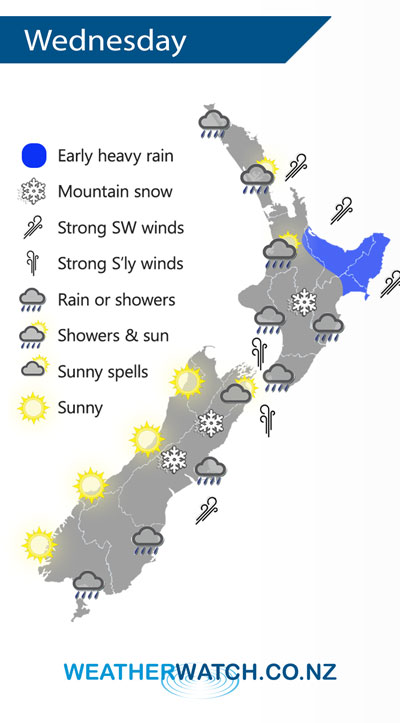
A strong cold southwesterly airflow covers New Zealand on Wednesday, easing over the South Island later in the day as a ridge of high pressure starts to push in.
Rain or showers for most regions on Wednesday however the West Coast of the South Island and Nelson gets a sunny day. Winds are strong from the south or southwest for many areas, easing from the south this evening.
Snow to 400m for eastern South Island regions gradually lifts during the day, flurries to 500m for hills and ranges about the Central Plateau and southwards in the North Island gradually lift during the day also.
Watch out for frosty conditions overnight especially about the inner South Island.
By Weather Analyst Aaron Wilkinson – WeatherWatch.co.nz
Comments
Latest Video

NZ 7 day forecast: Showers, temp changes and heavy West Coast rain
NZ has a fairly messy forecast over the next 7 days, but the main feature will be heavy rain on…
Related Articles
NZ 7 day forecast: Showers, temp changes and heavy West Coast rain
NZ has a fairly messy forecast over the next 7 days, but the main feature will be heavy rain on…

Cold fronts continue, wind & rain for some Fri/Sat
Wet weather is moving over the North Island today, while the South Island has drier skies – ahead of another…

Cold fronts vs high pressure
A cold front is moving up NZ today and into Tuesday, but will fall apart as it heads north and…


Guest on 10/04/2018 7:55pm
early heavy rain what crap niwa have the map wrong there hasn’t been much rain since feb what a crap year only two wet months out of five