
> From the WeatherWatch archives
Strong southwesterlies lies over the country today, a cold front within this flow races northwards over New Zealand during the day.
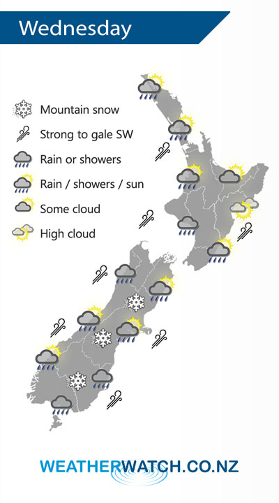
A mainly dry morning for the upper North Island then showers move in during the afternoon as southwesterlies strengthen, winds may rise to gale about western coastal areas then easing overnight. A dry morning for the lower and eastern North Island (although a few early showers clear Gisborne), showers move into Wellington and Wairarapa early afternoon then Hawkes Bay and Gisborne mid to late afternoon as a strong south to southwest change pushes through.
Morning rain eases to showers, clearing in the afternoon for the West Coast. A period of rain or showers develops around midday for Nelson / Marlborough then clearing in the evening, some snow possible to 500m for a time. Morning rain for Canterbury then easing to showers, clearing by evening south of Banks Peninsula then further north overnight. Snow may lower to 400m about Canterbury before clearing away. Early rain eases to showers about Southland / Otago then long dry spells developing in the evening, snow flurries to 300m.
By Weather Analyst Aaron Wilkinson – WeatherWatch.co.nz
Latest Video

Cold weekend, frosts return with high pressure, then a low late next week
The subantarctic airflow spreads over NZ today/tonight and into Saturday, dropping temperatures nationwide. Snow flurries are possible today to lower…
Related Articles
Cold weekend, frosts return with high pressure, then a low late next week
The subantarctic airflow spreads over NZ today/tonight and into Saturday, dropping temperatures nationwide. Snow flurries are possible today to lower…

Wintry burst of weather: Snow, squally showers then sunshine & frosts
A polar change (another one!) arrives on Friday for the South Island and goes nationwide on Saturday, leaving NZ under…

Antarctic southerly for parts of NZ Fri & Sat
For the first time this year a southerly from off Antarctica is heading towards the South Island, followed by more…

