
> From the WeatherWatch archives
A low passes over and away to the east of New Zealand on Wednesday gradually letting in a cold southwesterly airflow.
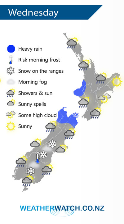
Showers for the North Island on Wednesday, especially in the west and north during the afternoon / evening as a front moves over. Showers may be heavy at times, perhaps even some thunder about the likes of Taranaki. A mainly dry day for Hawkes Bay and Gisborne.
Early heavy rain eases about Nelson / Marlborough then expect the odd shower. A few early showers clear for the central South Island then some sun may break through, later on a cold south to southwest change brings rain with snow developing on the mountain ranges. A chance of frost and fog once again in the morning for the lower South Island, especially inland. A dry start for Southland and Otago then rain developing with cold southwesterly winds, snow develops on the mountain ranges for a time before clearing overnight.
By Weather Analyst Aaron Wilkinson – WeatherWatch.co.nz
Latest Video

NZ: 8 Day outlook as gales & rain ease, high pressure builds
Damaging wind gusts and heavy rain will continue to affect some parts of the North Island and brushing Marlborough today…
Related Articles
NZ: 8 Day outlook as gales & rain ease, high pressure builds
Damaging wind gusts and heavy rain will continue to affect some parts of the North Island and brushing Marlborough today…

Pockets of hit & miss heavy rain, snow moves northwards
Low pressure continues to slowly move across the upper North Island and for some that will bring the sun out,…

Slow go for northern low & southern cold
For the next few days low pressure will crawl over the upper North Island, driving in rain as far south…

