InfoGraphic: The Big Picture for Tuesday / Wednesday
28/10/2019 6:00pm

> From the WeatherWatch archives
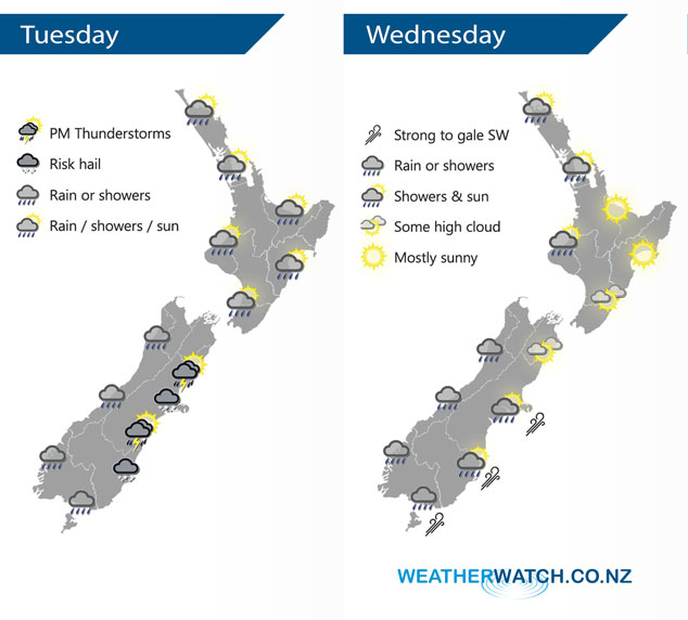
A southwesterly airflow lies over New Zealand today, becoming unstable for eastern regions in the afternoon. Southwesterlies ease over the North Island on Wednesday, meanwhile west to northwest winds build over the South Island ahead of a cold front which hits Southland around midday then pushing northwards to reach Cook Strait around midnight.
Morning rain or showers for the upper North Island then easing and sun breaks through in the afternoon, the odd shower and sunny spells for Taranaki through to Kapiti. Mainly dry in the east however showers develop this afternoon about Hawkes Bay and Gisborne, a few may become heavy with a risk of hail then clearing tonight. Rain this morning for the West Coast of the South Island then easing to showers, a dry and mostly sunny day for Nelson. Canterbury and Marlborough are mostly sunny, southwesterlies push through Canterbury around midday bringing showers, some heavy with a risk of thunderstorms and hail. Showers with a risk of hail / thunder move into Marlborough during this afternoon. Showers for Southland and Otago, some may become heavy with hail for North Otago then easing before evening.
The odd shower for the western North Island on Wednesday, mainly sunny conditions in the east. Rain or showers for the West Coast of the South Island. Dry for Nelson and Marlborough, risk of a shower later in the evening. Rain hits the lower South Island early afternoon then reaching Canterbury in the evening with a gusty southwest change, perhaps reaching up to gale along the coast. Rain mostly clears in the the east overnight.
By Weather Analyst Aaron Wilkinson – WeatherWatch.co.nz
Latest Video

Cold weekend, frosts return with high pressure, then a low late next week
The subantarctic airflow spreads over NZ today/tonight and into Saturday, dropping temperatures nationwide. Snow flurries are possible today to lower…
Related Articles
Cold weekend, frosts return with high pressure, then a low late next week
The subantarctic airflow spreads over NZ today/tonight and into Saturday, dropping temperatures nationwide. Snow flurries are possible today to lower…

Wintry burst of weather: Snow, squally showers then sunshine & frosts
A polar change (another one!) arrives on Friday for the South Island and goes nationwide on Saturday, leaving NZ under…

Antarctic southerly for parts of NZ Fri & Sat
For the first time this year a southerly from off Antarctica is heading towards the South Island, followed by more…

