InfoGraphic: The Big Picture for Tuesday / Wednesday
30/09/2019 6:00pm

> From the WeatherWatch archives
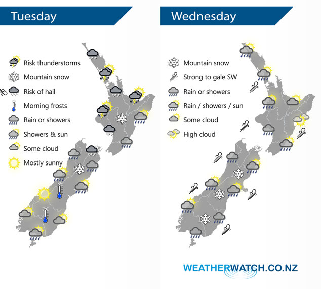
A cold south to southwesterly airflow over the South Island spreads over the North Island today. Strong southwesterlies remain over the country on Wednesday.
Showers, becoming heavy with a risk of thunderstorms and hail in this afternoon for the upper North Island as southwesterlies freshen. Conditions ease later in the evening. Rain develops about Wellington and Wairarapa this morning then spreading northwards into Hawkes Bay and Gisborne in the afternoon. Snow lowers about the Central Plateau overnight to 600m. Rain or showers about the upper South Island eases during the day, gradually clearing from the south. Morning snow to 300m about Canterbury then clearing, 500m for Marlborough; gradually lifting and clearing. Fairly dry about the lower South Island but the odd shower may pester Southland, mainly this morning.
A mainly dry morning for the upper North Island then showers move in during the afternoon as southwesterlies strengthen, winds may rise to gale about western coastal areas then easing overnight. A dry morning for the lower and eastern North Island (although a few early showers clear Gisborne), showers move into Wellington and Wairarapa early afternoon then Hawkes Bay and Gisborne mid to late afternoon as a strong south to southwest change pushes through. Morning rain eases to showers, clearing in the afternoon for the West Coast. A period of rain or showers develops around midday for Nelson / Marlborough then clearing in the evening, some snow possible to 500m for a time. Morning rain for Canterbury then easing to showers, clearing by evening south of Banks Peninsula then further north overnight. Snow may lower to 400m about Canterbury before clearing away. Early rain eases to showers about Southland / Otago then long dry spells developing in the evening, snow flurries to 300m.
By Weather Analyst Aaron Wilkinson – WeatherWatch.co.nz
Latest Video

Matariki, the long weekend + the outlook for next week
Wet weather and cloud continues along the eastern side of the country with the heaviest rain now moving into northern…
Related Articles
Matariki, the long weekend + the outlook for next week
Wet weather and cloud continues along the eastern side of the country with the heaviest rain now moving into northern…

More eastern rain, but a drier long weekend coming
Rain continues today along the eastern South Island and lower North Island, coming in from the east with heavy falls….

More heavy rain, snow – but large dry areas, especially as we go into the long weekend
Heavy rain will continue for parts of Canterbury and Marlborough over the next day or two and it will gradually…

