InfoGraphic: The Big Picture for Tuesday / Wednesday
27/05/2019 7:00pm

> From the WeatherWatch archives
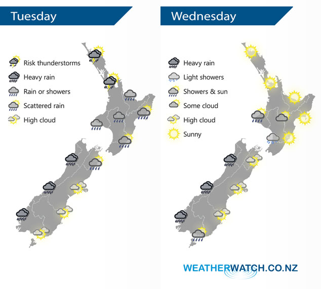
Northeasterlies over New Zealand today, tending northerly this afternoon and finally westerly overnight as a series of fronts moves through. The flow tilts northwesterly on Wednesday, blustery for the South Island.
As a front sweeps down over the upper North Island this morning / early afternoon there may be isolated heavy falls and thunderstorms then easing. Rain develops about Taranaki this morning, spreading to Kapiti by midday, a sunny morning for the east coast before clouding over with scattered rain after midday. Heavy rain for the South Island’s West Coast, mainly dry in the east with some high cloud although Nelson and Marlborough will likely see some rain.
Mostly sunny for the upper and eastern North Island on Wednesday with warm temperatures, a little cloudier in the west with the risk of a shower or two. The West Coast of the South Island sees showers turn to rain in the morning, becoming heavy with thunderstorms at times afternoon onwards. Mostly sunny with some high cloud out east. For the lower South Island south of Otago Peninsula expect some morning sun then scattered rain develops in the afternoon, clearing evening although continuing about Central Otago.
By Weather Analyst Aaron Wilkinson – WeatherWatch.co.nz
Latest Video

Cold weekend, frosts return with high pressure, then a low late next week
The subantarctic airflow spreads over NZ today/tonight and into Saturday, dropping temperatures nationwide. Snow flurries are possible today to lower…
Related Articles
Cold weekend, frosts return with high pressure, then a low late next week
The subantarctic airflow spreads over NZ today/tonight and into Saturday, dropping temperatures nationwide. Snow flurries are possible today to lower…

Wintry burst of weather: Snow, squally showers then sunshine & frosts
A polar change (another one!) arrives on Friday for the South Island and goes nationwide on Saturday, leaving NZ under…

Antarctic southerly for parts of NZ Fri & Sat
For the first time this year a southerly from off Antarctica is heading towards the South Island, followed by more…

