InfoGraphic: The Big Picture for Tuesday / Wednesday
5/03/2018 6:00pm

> From the WeatherWatch archives
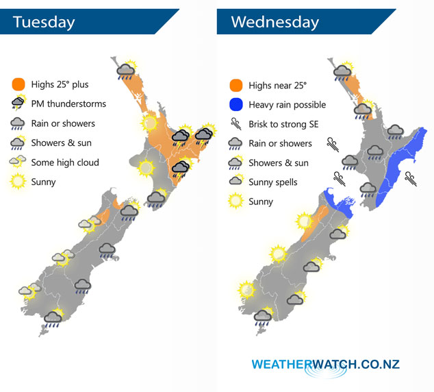
A weak area of low pressure covers the North Island today bringing a chance of downpours, especially in the east with thunderstorms. Rain for the east of the South Island with cooler southerlies, drier in the west. Conditions ease over the South Island on Wednesday however a low and southeasterly airflow combine to bring unsettled weather further north.
Today sees rain push northwards along the east coast of the South Island as cool southerlies move northwards, drier in the west although just inland about the main divide some rain will push over from the east.
Another mainly dry morning for the North Island then showers develop in the afternoon especially about Northland, Bay Of Plenty and along the east coast. Showers in the east and about the Bay Of Plenty (more so inland Bay Of Plenty) becoming heavy with a risk of thunderstorms which ease later in the evening.
A fairly unsettled day for most of the North Island on Wednesday with areas of rain, heavy falls look most likely to occur along the east coast however there is a chance rain could be heavy at times in the west. In the afternoon showers about Northland could contain thunderstorms.
Heavy rain about Nelson and Marlborough is possible only very early in the morning then it will ease away and conditions are fairly cloudy although Nelson may see some afternoon sun. Mostly cloudy about Canterbury with the chance of a light shower or drizzle patch about inland areas for much of the day, some sun breaks through in the afternoon near the coast. A mostly sunny morning for the far south then a small southwest flick brings a light shower or two to Southland from afternoon then Otago late afternoon or evening. A mainly sunny day for the West Coast.
By Weather Analyst Aaron Wilkinson – WeatherWatch.co.nz
Latest Video

Cold weekend, frosts return with high pressure, then a low late next week
The subantarctic airflow spreads over NZ today/tonight and into Saturday, dropping temperatures nationwide. Snow flurries are possible today to lower…
Related Articles
Cold weekend, frosts return with high pressure, then a low late next week
The subantarctic airflow spreads over NZ today/tonight and into Saturday, dropping temperatures nationwide. Snow flurries are possible today to lower…

Wintry burst of weather: Snow, squally showers then sunshine & frosts
A polar change (another one!) arrives on Friday for the South Island and goes nationwide on Saturday, leaving NZ under…

Antarctic southerly for parts of NZ Fri & Sat
For the first time this year a southerly from off Antarctica is heading towards the South Island, followed by more…

