InfoGraphic: The Big Picture for Tuesday / Wednesday
21/01/2019 6:00pm

> From the WeatherWatch archives
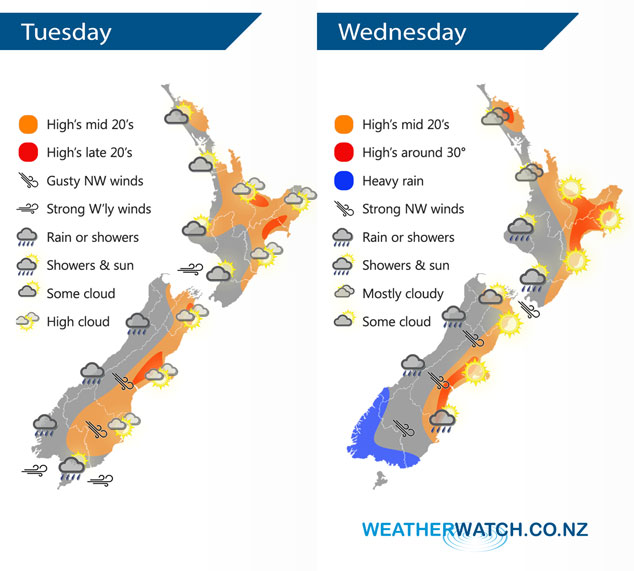
An anticyclone in the Tasman Sea directs a fresh west to southwesterly airflow over New Zealand today. High pressure to the north of New Zealand and a front moving in from the south brings a gusty northwesterly airflow over the country on Wednesday. This front moves onto the lower South Island early afternoon arriving at the lower North Island overnight.
Some cloud for the western North Island today, mainly dry. Sunnier out east with warm temperatures. Rain or showers for the West Coast of the South Island, morning showers about Southland / the Catlins clear then mostly sunny. Mostly sunny for Canterbury, Marlborough and Nelson.
Fairly cloudy for the upper North Island on Wednesday but some sun may break through from afternoon, more so the further east you go. The Bay Of Plenty is mostly sunny after any morning cloud breaks away. Cloudy areas with a shower or two for the lower western North Island (Taranaki through to Kapiti), some overnight rain. Mainly sunny for the east coast, overnight rain for Wairarapa. Rain for the West Coast of the South Island, becoming heavy from afternoon in the south then spreading northwards, clearing overnight. Mostly sunny for the east coast, a period of rain moves northwards during the afternoon and evening with a gusty southwest change.
By Weather Analyst Aaron Wilkinson – WeatherWatch.co.nz
Latest Video

Cold weekend, frosts return with high pressure, then a low late next week
The subantarctic airflow spreads over NZ today/tonight and into Saturday, dropping temperatures nationwide. Snow flurries are possible today to lower…
Related Articles
Cold weekend, frosts return with high pressure, then a low late next week
The subantarctic airflow spreads over NZ today/tonight and into Saturday, dropping temperatures nationwide. Snow flurries are possible today to lower…

Wintry burst of weather: Snow, squally showers then sunshine & frosts
A polar change (another one!) arrives on Friday for the South Island and goes nationwide on Saturday, leaving NZ under…

Antarctic southerly for parts of NZ Fri & Sat
For the first time this year a southerly from off Antarctica is heading towards the South Island, followed by more…

