InfoGraphic: The Big Picture for Tuesday / Wednesday
29/10/2018 6:00pm

> From the WeatherWatch archives
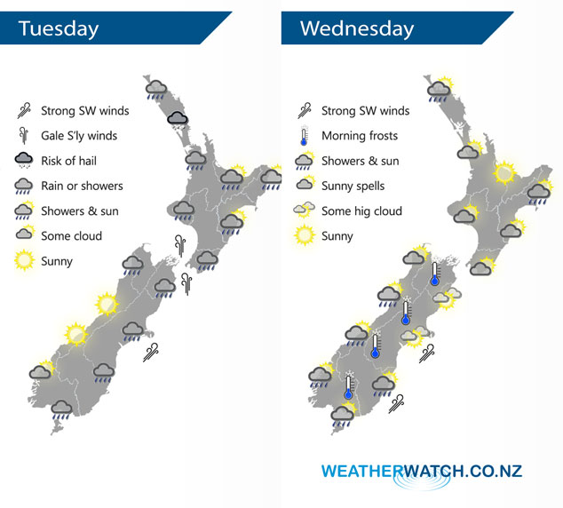
A cold southwesterly airflow lies over New Zealand today as a low passes out to the east. A ridge brings a period of settled weather for New Zealand on Wednesday, however not for long as a cold front pushes onto the lower South Island later in the afternoon.
Showers for the western North Island today, heavy at times. Some rain in the afternoon Taranaki southwards then easing at night. Showers may be heavy with hail at times for Northland. Rain about Wairarapa spreads northwards during this afternoon. Southerly winds rising to gale through Cook Strait from afternoon. Rain for the eastern South Island easing to showers this afternoon, clearing later in the evening / overnight for most then watch for frosts around dawn on Wednesday morning. Mostly sunny for the West Coast during the day, a few showers for Buller however.
Mostly sunny for the upper North Island on Wednesday, there may be a few clearing morning showers for Northland. Morning showers clear Hawkes Bay / Gisborne then sun increases. Mostly sunny in the west Taranaki southwards then cloud increases in the evening, rain moves in overnight. Mostly sunny for a majority of the South Island with developing high cloud, morning frosts are possible especially for inland areas. Rain moves into Fiordland around midday then pushes northwards in the evening. Rain moves into Southland late afternoon then Otago in the evening, Canterbury overnight with gusty southwest winds, strong about the coast.
By Weather Analyst Aaron Wilkinson – WeatherWatch.co.nz
Latest Video

Cold weekend, frosts return with high pressure, then a low late next week
The subantarctic airflow spreads over NZ today/tonight and into Saturday, dropping temperatures nationwide. Snow flurries are possible today to lower…
Related Articles
Cold weekend, frosts return with high pressure, then a low late next week
The subantarctic airflow spreads over NZ today/tonight and into Saturday, dropping temperatures nationwide. Snow flurries are possible today to lower…

Wintry burst of weather: Snow, squally showers then sunshine & frosts
A polar change (another one!) arrives on Friday for the South Island and goes nationwide on Saturday, leaving NZ under…

Antarctic southerly for parts of NZ Fri & Sat
For the first time this year a southerly from off Antarctica is heading towards the South Island, followed by more…

