InfoGraphic: The Big Picture for Tuesday / Wednesday
1/10/2018 6:00pm

> From the WeatherWatch archives
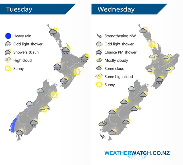
A southwesterly airflow lies over New Zealand today, a front within this flow clears the upper North Island this morning meanwhile a cold front moves onto the lower South Island before midday. An anticyclone brings mainly settled conditions on Wednesday.
Morning rain clears most of the upper North Island today then sunny areas develop, showers may hang around for Northland till evening however. A dry day for the east coast however Gisborne has rain this morning then clearing, a few showers at times in the west Taranaki southwards especially morning. Mostly cloudy for the West Coast of the South Island, chance of a shower and some heavy rain moves into Fiordland for a time. Mainly dry in the east with some developing high cloud, rain moves into Southland during this morning then moving northwards in the form of showers reaching Canterbury this evening.
Mainly settled for a majority of the North Island on Wednesday, chance of a few isolated shower in the afternoon about the ranges of Wairarapa otherwise mainly dry. Temperatures getting into the high teens for most, perhaps even early twenties about Northland. The South Island has slightly cloudier skies in the west, perhaps even a light shower or two for Buller. The east coast sees areas of morning cloud break to mostly sunny conditions, east to northeasterly winds freshen up in the afternoon.
By Weather Analyst Aaron Wilkinson – WeatherWatch.co.nz
Latest Video

Cold weekend, frosts return with high pressure, then a low late next week
The subantarctic airflow spreads over NZ today/tonight and into Saturday, dropping temperatures nationwide. Snow flurries are possible today to lower…
Related Articles
Cold weekend, frosts return with high pressure, then a low late next week
The subantarctic airflow spreads over NZ today/tonight and into Saturday, dropping temperatures nationwide. Snow flurries are possible today to lower…

Wintry burst of weather: Snow, squally showers then sunshine & frosts
A polar change (another one!) arrives on Friday for the South Island and goes nationwide on Saturday, leaving NZ under…

Antarctic southerly for parts of NZ Fri & Sat
For the first time this year a southerly from off Antarctica is heading towards the South Island, followed by more…

