InfoGraphic: The Big Picture for Tuesday / Wednesday
27/08/2018 7:00pm

> From the WeatherWatch archives
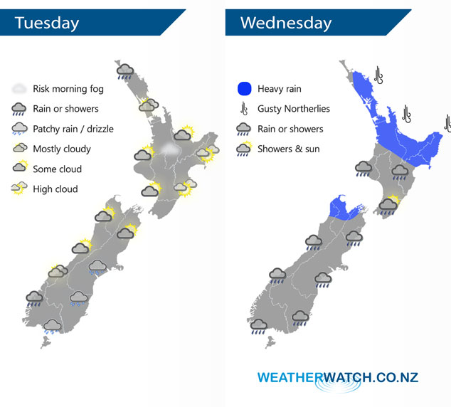
A low churns away west of New Zealand in the Tasman Sea on Tuesday, an east to northeasterly airflow gradually increases over the country during the day. This low continues to sit in the Tasman Sea on Wednesday with an occluded front stretching out from this low passing over New Zealand from west to east during the day.
Thickening cloud across much of the North Island today, chance of a shower or two from afternoon in the west. Rain moves into Northland this evening then pushes southwards overnight. Mostly sunny for the east coast with some high cloud. The South Island sees cloudy skies and patchy showers / drizzle develop in the east, mainly Banks Peninsula southwards. Morning cloud may break to some sun along the West Coast. Rain moves into Nelson overnight.
Rain for the upper North Island is heavy at times, slowly easing from the west late afternoon onwards. Not easing about the Bay Of Plenty till overnight. Morning rain for the lower North Island then easing to showers, some sun possible from afternoon especially about the Wairarapa. Rain for the West Coast of the South Island eases to showers around midday on Wednesday, rain about Nelson and Marlborough with a chance of heavy falls clearing early afternoon with areas of sun breaking through. Some morning rain for the east coast then sunny areas develop in the afternoon.
By Weather Analyst Aaron Wilkinson – WeatherWatch.co.nz
Latest Video

Cold weekend, frosts return with high pressure, then a low late next week
The subantarctic airflow spreads over NZ today/tonight and into Saturday, dropping temperatures nationwide. Snow flurries are possible today to lower…
Related Articles
Cold weekend, frosts return with high pressure, then a low late next week
The subantarctic airflow spreads over NZ today/tonight and into Saturday, dropping temperatures nationwide. Snow flurries are possible today to lower…

Wintry burst of weather: Snow, squally showers then sunshine & frosts
A polar change (another one!) arrives on Friday for the South Island and goes nationwide on Saturday, leaving NZ under…

Antarctic southerly for parts of NZ Fri & Sat
For the first time this year a southerly from off Antarctica is heading towards the South Island, followed by more…

