InfoGraphic: The Big Picture for Tuesday / Wednesday
13/08/2018 7:00pm

> From the WeatherWatch archives
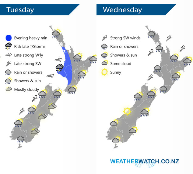
A low pressure system gradually passes over New Zealand today moving from west to east, winds from the north changing to the southwest during the evening and overnight. A weak ridge of high pressure moves onto the South Island on Wednesday morning, southwesterlies ease later in the day elsewhere.
Early rain eases to showers for the western North Island today, in the evening or overnight rain picks up with heavy falls and thunderstorms possible. For the east coast early rain clears then becoming mostly sunny, in the evening scattered falls may move in again spreading from the west. For the South Island expect rain or showers in the north, west and south, the east coast doesn’t really see widespread rain or showers till evening / overnight.
A showery day for much of the North Island on Wednesday with fresh cool southwesterly winds, long dry spells develop by evening. Showers clear for the upper South Island in the morning then sunny spells increase with southwesterlies easing. Becoming sunny early in the morning for the lower South Island, some cloud and drizzle moves into Fiordland in the evening.
By Weather Analyst Aaron Wilkinson – WeatherWatch.co.nz
Latest Video

NZ: 8 Day outlook as gales & rain ease, high pressure builds
Damaging wind gusts and heavy rain will continue to affect some parts of the North Island and brushing Marlborough today…
Related Articles
NZ: 8 Day outlook as gales & rain ease, high pressure builds
Damaging wind gusts and heavy rain will continue to affect some parts of the North Island and brushing Marlborough today…

Pockets of hit & miss heavy rain, snow moves northwards
Low pressure continues to slowly move across the upper North Island and for some that will bring the sun out,…

Slow go for northern low & southern cold
For the next few days low pressure will crawl over the upper North Island, driving in rain as far south…

