InfoGraphic: The Big Picture for Tuesday / Wednesday
6/08/2018 7:00pm

> From the WeatherWatch archives
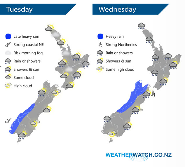
A weak ridge of high pressure lies over the North Island today while northerlies build for the South Island, a front pushes onto the West Coast in the evening. This front sweeps northwards over New Zealand on Wednesday bringing rain or showers to most regions for a time, heavy in the west.
A mix of sun and cloud for much of the North Island today, a shower or two may crop up in the afternoon about Auckland, Waikato and Bay Of Plenty. Rain or showers about Hawkes Bay and Gisborne ease. For the South Island expect building cloud in the west, the odd light shower from afternoon then rain moves in by evening with heavy falls about South Westland. Dry in the east with high cloud after midday.
As a front sweeps northwards over New Zealand on Wednesday expect heavy rain for the West Coast of the South Island to ease from afternoon, rain may become heavy about Taranaki in the afternoon then easing there in the evening. A few spots of rain spread into eastern regions for a time. A period of showers moves through Otago in the afternoon with a southwest change, reaching Canterbury in the evening.
By Weather Analyst Aaron Wilkinson – WeatherWatch.co.nz
Latest Video

Wintry weather coming: Snow, rain, wind & sunshine
A cold front is moving into NZ from Friday to Sunday with low pressure developing west of NZ and then…
Related Articles

Polar airflow + northern low = pockets of heavy rain & snow
A colder change is coming – and so too is a large low which will develop and grow over northern…
Wintry weather coming: Snow, rain, wind & sunshine
A cold front is moving into NZ from Friday to Sunday with low pressure developing west of NZ and then…

ClimateWatch: JULY outlook & what El Niño means for NZ
El Niño is officially here and still getting stronger in the months ahead, but it’s harder to notice its effects…

