InfoGraphic: The Big Picture for Tuesday / Wednesday
30/07/2018 7:00pm

> From the WeatherWatch archives
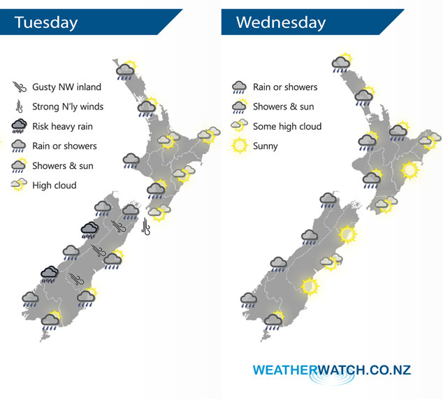
A front moves northwards over the upper South Island this morning then pushes onto the western North Island late afternoon / evening. Winds from the north ahead of the front and changing west to northwest in behind. A northwesterly airflow lies over New Zealand on Wednesday with a few showers or some rain in the west, mainly dry in the east.
Dry for the western North Island at first today with developing high cloud, late afternoon or evening showers move in from the west. Sunny in the east with some high cloud. Rain for the West Coast of the South Island may be heavy, a few spots of rain out east mainly early in the morning then some sun breaks through.
A few showers for the upper North Island on Wednesday morning then clearing with sunny areas increasing, showers may not clear Bay Of Plenty till late afternoon or evening. For the lower western North Island expect some cloud with the odd shower at times during the day. Mainly dry on the east coast although there may be a few spots of rain spread into Gisborne at times. Rain or showers for the West Coast of the South Island, mainly sunny in the east although a few spots of rain may affect Southland and Otago for a brief time.
By Weather Analyst Aaron Wilkinson – WeatherWatch.co.nz
Latest Video

Cold weekend, frosts return with high pressure, then a low late next week
The subantarctic airflow spreads over NZ today/tonight and into Saturday, dropping temperatures nationwide. Snow flurries are possible today to lower…
Related Articles
Cold weekend, frosts return with high pressure, then a low late next week
The subantarctic airflow spreads over NZ today/tonight and into Saturday, dropping temperatures nationwide. Snow flurries are possible today to lower…

Wintry burst of weather: Snow, squally showers then sunshine & frosts
A polar change (another one!) arrives on Friday for the South Island and goes nationwide on Saturday, leaving NZ under…

Antarctic southerly for parts of NZ Fri & Sat
For the first time this year a southerly from off Antarctica is heading towards the South Island, followed by more…

