InfoGraphic: The Big Picture for Tuesday / Wednesday
25/06/2018 7:00pm

> From the WeatherWatch archives
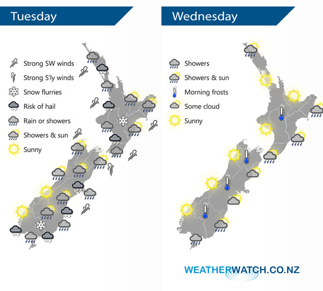
A trough pushes onto the North Island this morning bringing very unsettled weather and strong cold southwesterly winds. Cold southwesterlies lie over the South Island also. A southwesterly airflow continues on Wednesday however conditions will have eased for most regions.
Quite unsettled over the North Island today as a trough pushes northwards bringing very cold temperatures, heavy rain for a time and some hail. Snow lowers to 400m about the Central Plateau.
Showers about Canterbury (possibly heavy with hail and snow flurries to 300m) becoming quite coastal during the morning and clearing away from inland areas. The West Coast, Nelson and Marlborough sees morning showers clear then sunny areas increase. Showers about Southland and Otago may be heavy early in the morning with hail then easing, snow flurries to 200m at first then lifting during the day.
A calmer picture on Wednesday with most regions seeing some sun, the odd shower persists about Southland however and coastal Otago (mainly morning for coastal Otago). Showers also clip the coastal fringes along the east coast of the North Island, just inland conditions are drier with some sun.
By Weather Analyst Aaron Wilkinson – WeatherWatch.co.nz
Latest Video

Cold weekend, frosts return with high pressure, then a low late next week
The subantarctic airflow spreads over NZ today/tonight and into Saturday, dropping temperatures nationwide. Snow flurries are possible today to lower…
Related Articles
Cold weekend, frosts return with high pressure, then a low late next week
The subantarctic airflow spreads over NZ today/tonight and into Saturday, dropping temperatures nationwide. Snow flurries are possible today to lower…

Wintry burst of weather: Snow, squally showers then sunshine & frosts
A polar change (another one!) arrives on Friday for the South Island and goes nationwide on Saturday, leaving NZ under…

Antarctic southerly for parts of NZ Fri & Sat
For the first time this year a southerly from off Antarctica is heading towards the South Island, followed by more…

