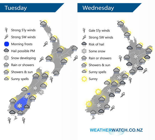
InfoGraphic: The Big Picture for Tuesday / Wednesday
4/06/2018 7:00pm

> From the WeatherWatch archives
A low pressure system peels away to the east of the North Island today, this combined with a high moving into the Tasman Sea will bring a period of cold southerlies for New Zealand starting about the lower South Island from late morning then gradually moving northwards. This strong cold southerly airflow over the South Island spreads over the North Island on Wednesday bringing rain with a risk of heavy falls and hail. Also some snow about the Central Plateau.
Showers or rain eases over the North Island today and dry areas become more frequent from afternoon, showers may not clear the east coast till evening. Overnight rain moves into Wellington. For the South Island showers clear in the northeast this morning, mainly dry otherwise. Late morning cold southerlies move into Southland bringing showers, possibly heavy with hail. These showers move into Otago during the afternoon then Canterbury in the evening. Some snow lowers in the evening to 200m about Southland / Otago, perhaps near sea level at times overnight. Snow lowering to 200m overnight for Canterbury.
Rain or showers for most regions on Wednesday, there may be hail at times also. Some inland parts of the South Island may stay quite sheltered apart from an initial burst of precipitation in the morning. Snow to low levels (200 to 100m) from Southland through to Canterbury, 400m about Marlborough through to the Central North Island in the evening. Winds blustery and cold from the south or southwest, gales through Cook Strait.

By Weather Analyst Aaron Wilkinson – WeatherWatch.co.nz
Comments
Before you add a new comment, take note this story was published on 4 Jun 2018.


Add new comment