InfoGraphic: The Big Picture for Tuesday / Wednesday
28/05/2018 7:00pm

> From the WeatherWatch archives
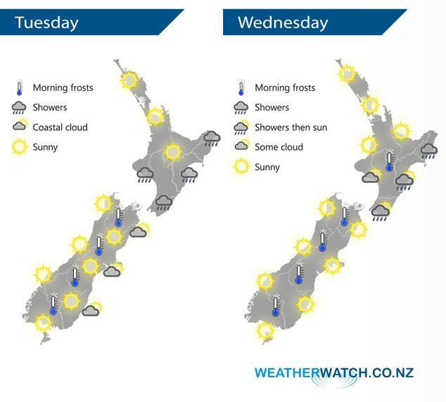
An anticyclone lies over the South Island today while a southerly airflow lies over the North Island. The anticyclone covers most of the country on Wednesday.
Looking sunny for many regions today however it will be a frosty start especially for the inner South Island where heavy frosts are possible. Just some coastal cloud possible along the South Island’s east coast. For the North Island a few showers continue in the south, east and west up through to Taranaki. Mainly sunny elsewhere.
Mostly sunny for plenty of regions on Wednesday, morning frosts are likely once again especially for the inland South Island but also inner North Island areas. Just a shower or two continuing to skim the North Island’s east coast during the day, but slowly easing and pulling away.
By Weather Analyst Aaron Wilkinson – WeatherWatch.co.nz
Latest Video

Cold weekend, frosts return with high pressure, then a low late next week
The subantarctic airflow spreads over NZ today/tonight and into Saturday, dropping temperatures nationwide. Snow flurries are possible today to lower…
Related Articles
Cold weekend, frosts return with high pressure, then a low late next week
The subantarctic airflow spreads over NZ today/tonight and into Saturday, dropping temperatures nationwide. Snow flurries are possible today to lower…

Wintry burst of weather: Snow, squally showers then sunshine & frosts
A polar change (another one!) arrives on Friday for the South Island and goes nationwide on Saturday, leaving NZ under…

Antarctic southerly for parts of NZ Fri & Sat
For the first time this year a southerly from off Antarctica is heading towards the South Island, followed by more…

