
> From the WeatherWatch archives
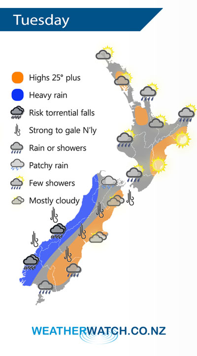
A strengthening northerly airflow lies over New Zealand today, a front moves onto the lower South Island this afternoon then slowly moves northwards.
Mainly dry for the North Island on Tuesday, a shower or two possible about some extremities. The east coast once again is mainly sunny.
Heavy rain for the West Coast of the South Island, torrential falls possible especially south of Greymouth. Mainly dry in the east with thick high cloud, rain moves into Southland around midday then pushes into Otago during the afternoon. Northerly winds will be a bit blustery especially about the alps where winds may gust to gale at times.
By Weather Analyst Aaron Wilkinson – WeatherWatch.co.nz
Latest Video

Cold weekend, frosts return with high pressure, then a low late next week
The subantarctic airflow spreads over NZ today/tonight and into Saturday, dropping temperatures nationwide. Snow flurries are possible today to lower…
Related Articles
Cold weekend, frosts return with high pressure, then a low late next week
The subantarctic airflow spreads over NZ today/tonight and into Saturday, dropping temperatures nationwide. Snow flurries are possible today to lower…

Wintry burst of weather: Snow, squally showers then sunshine & frosts
A polar change (another one!) arrives on Friday for the South Island and goes nationwide on Saturday, leaving NZ under…

Antarctic southerly for parts of NZ Fri & Sat
For the first time this year a southerly from off Antarctica is heading towards the South Island, followed by more…

