InfoGraphic: The Big Picture for Thursday / Friday
4/04/2018 8:43pm

> From the WeatherWatch archives
A ridge lies over New Zealand today extending out from an anticyclone centred in the Tasman Sea. A front pushes onto the lower South Island on Friday morning then weakens as it moves northwards.
Mainly settled over the country today due to an anticyclone. Morning cloud with the chance of a shower for the lower western North Island breaks away to a mostly sunny afternoon, out east some cloud and the risk of a light shower for Wairarapa this morning then gradually pushing northwards late afternoon or evening.
Mostly sunny for the West Coast of the South Island after morning cloud breaks away, staying a bit cloudy about Fiordland however with further showers there from afternoon. Mostly sunny in the east after morning cloud breaks away, Marlborough may see cloud be a bit more persistent during the day. Southland has the chance of a coastal shower in the morning.
Some cloud for the upper North Island on Friday although expect areas of sun especially in the afternoon, a chance of morning fog for the Waikato. Mostly sunny elsewhere for the North Island.
About the South Island expect mostly cloudy skies in the west, rain about South Westland is heavy at times then clearing later in the evening or overnight. In the east conditions are mainly dry and warm with some high cloud ahead of a southwest change, rain pushes into Southland in the morning, Otago around midday then southern Canterbury in the evening. Northwesterly winds ahead of this change are gusty about inland areas.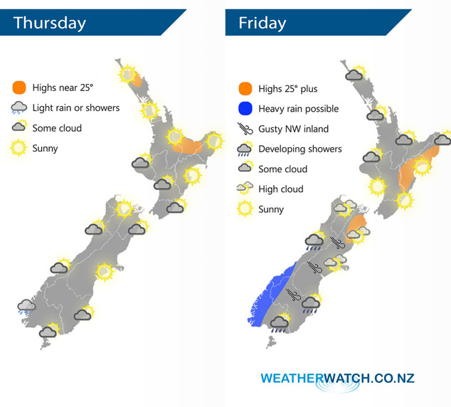
By Weather Analyst Aaron Wilkinson – WeatherWatch.co.nz
Latest Video

NZ 7 day forecast: Showers, temp changes and heavy West Coast rain
NZ has a fairly messy forecast over the next 7 days, but the main feature will be heavy rain on…
Related Articles
NZ 7 day forecast: Showers, temp changes and heavy West Coast rain
NZ has a fairly messy forecast over the next 7 days, but the main feature will be heavy rain on…

Cold fronts continue, wind & rain for some Fri/Sat
Wet weather is moving over the North Island today, while the South Island has drier skies – ahead of another…

Cold fronts vs high pressure
A cold front is moving up NZ today and into Tuesday, but will fall apart as it heads north and…

