InfoGraphic: The Big Picture for Thursday / Friday
30/10/2019 6:00pm

> From the WeatherWatch archives
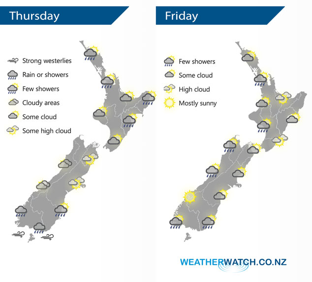
A cold front pushes northwards over the North Island during today however it weakens as it does. A westerly airflow builds over the South Island. A southwesterly airflow lies over the country on Friday.
A few showers about the eastern and upper North Island clear this morning then sunny areas increase, winds from the south or southwest, tending easterly in the afternoon along the east coast. A few showers about Fiordland, gradually spreading northwards along the West Coast later in the afternoon or evening. Morning cloud for Nelson and Marlborough then becoming mostly sunny. Canterbury has a mainly sunny day, light winds tend easterly in the afternoon. Showers for Southland with brisk to strong westerly winds, some rain possible for a time in the evening. Otago has sunny areas and increasing high cloud, a few spits or showers later in the day with westerlies tending southwest (becoming strong about the coast in the evening).
Cloudy areas for the western North Island on Friday, risk of a shower or two also mainly in the afternoon. Cloudy areas develop in the morning along the east coast with the risk of a shower, drying out in the afternoon with cloudy areas hanging around. A shower or two for the West Coast north of about Hokitika, sunnier skies further south. A mix of sun and cloud for Marlborough and Canterbury, a shower or two possible about Southland / Otago otherwise mainly dry.
By Weather Analyst Aaron Wilkinson – WeatherWatch.co.nz
Latest Video

Cold weekend, frosts return with high pressure, then a low late next week
The subantarctic airflow spreads over NZ today/tonight and into Saturday, dropping temperatures nationwide. Snow flurries are possible today to lower…
Related Articles
Cold weekend, frosts return with high pressure, then a low late next week
The subantarctic airflow spreads over NZ today/tonight and into Saturday, dropping temperatures nationwide. Snow flurries are possible today to lower…

Wintry burst of weather: Snow, squally showers then sunshine & frosts
A polar change (another one!) arrives on Friday for the South Island and goes nationwide on Saturday, leaving NZ under…

Antarctic southerly for parts of NZ Fri & Sat
For the first time this year a southerly from off Antarctica is heading towards the South Island, followed by more…

