InfoGraphic: The Big Picture for Thursday / Friday
14/03/2018 6:00pm

> From the WeatherWatch archives
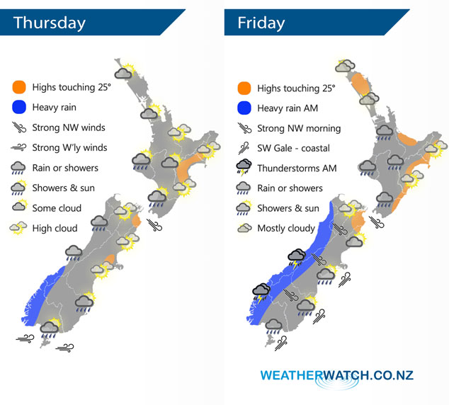
Northwesterlies strengthen today with a cold front pushing onto the lower South Island this evening. This front pushes northwards during Friday reaching the North Island in the afternoon, it will have weakened however.
Sunny spells for the western North Island today, Taranaki southwards sees slightly cloudier skies and the chance of a shower or two. Along the east coast and for the Bay Of Plenty expect sunny areas and some high cloud.
Some high cloud for the eastern South Island, cloudy in the west with showers. Rain about Fiordland from afternoon with a chance of heavy falls, possible thunderstorms from later in the evening / overnight. Northwesterlies about inland parts of the South Island may gust to gale force later in the evening or overnight.
Showers for the west of the North Island Waikato southwards, clearing in the evening. Auckland may see a shower or two in the afternoon or the city may stay mainly dry with showers just south of the city. Out east conditions are mainly dry however a southwest change late afternoon or evening may bring a few showers.
Morning heavy rain and possible thunderstorms for the West Coast of the South Island then clearing and sunny areas increasing in the afternoon. Strong northwesterly winds in the east with gales in the high country then a southwest change (coastal gales Banks Peninsula southwards) races northwards in the morning, staying mainly dry for Canterbury and Marlborough. Morning showers for Southland could contain some small hail.
Overnight conditions becoming quite cold for the inner South Island with light frosts possible by dawn on Saturday.
By Weather Analyst Aaron Wilkinson – WeatherWatch.co.nz
Latest Video

Cold weekend, frosts return with high pressure, then a low late next week
The subantarctic airflow spreads over NZ today/tonight and into Saturday, dropping temperatures nationwide. Snow flurries are possible today to lower…
Related Articles
Cold weekend, frosts return with high pressure, then a low late next week
The subantarctic airflow spreads over NZ today/tonight and into Saturday, dropping temperatures nationwide. Snow flurries are possible today to lower…

Wintry burst of weather: Snow, squally showers then sunshine & frosts
A polar change (another one!) arrives on Friday for the South Island and goes nationwide on Saturday, leaving NZ under…

Antarctic southerly for parts of NZ Fri & Sat
For the first time this year a southerly from off Antarctica is heading towards the South Island, followed by more…

