InfoGraphic: The Big Picture for Thursday / Friday
12/06/2019 7:00pm

> From the WeatherWatch archives
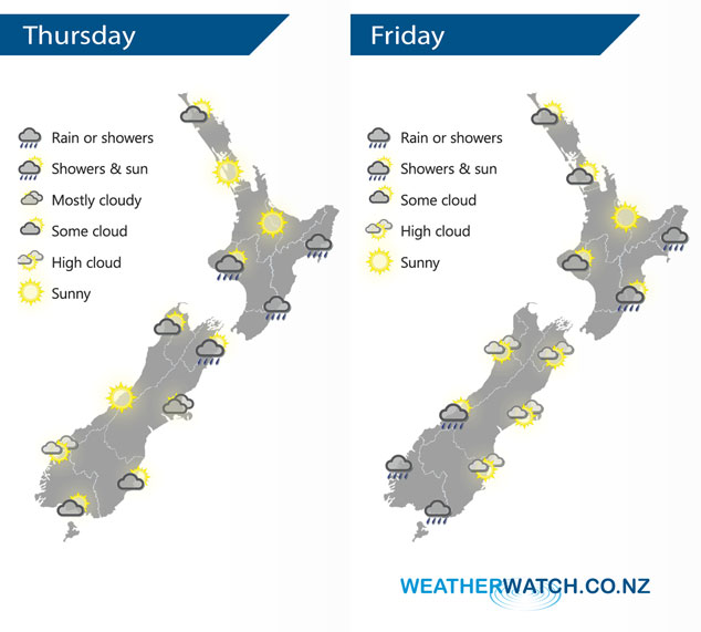
A ridge of high pressure lies over the South Island today, southeasterlies for the North Island. Similar conditions prevail on Friday, a front moves onto the lower South Island from afternoon.
Showers or some rain at times for the eastern North Island today, sunnier conditions out west although there may be some cloud at times especially for Northland with isolated showers possible late afternoon / evening. Also some fog possible this morning about Auckland and the Waikato. Morning showers Taranaki southwards in the west clear. Expect a few showers about Marlborough and perhaps this morning for Nelson, mostly cloudy down through to about Banks Peninsula in the east. Morning cloud south of Banks Peninsula breaks then expect sunny areas and some high cloud. Mostly sunny conditions for the West Coast with some high cloud.
Rain or showers once again for the eastern North Island on Friday, sunny spells out west although showers may move into Northland / northern Auckland at times. Any morning showers clear Marlborough otherwise mainly dry. Rain moves into Fiordland by midday then pushes a little further north in the evening and overnight. Some rain moves into Southland during the afternoon then Otago in the evening with the passage of a front.
By Weather Analyst Aaron Wilkinson – WeatherWatch.co.nz
Latest Video

Cold weekend, frosts return with high pressure, then a low late next week
The subantarctic airflow spreads over NZ today/tonight and into Saturday, dropping temperatures nationwide. Snow flurries are possible today to lower…
Related Articles
Cold weekend, frosts return with high pressure, then a low late next week
The subantarctic airflow spreads over NZ today/tonight and into Saturday, dropping temperatures nationwide. Snow flurries are possible today to lower…

Wintry burst of weather: Snow, squally showers then sunshine & frosts
A polar change (another one!) arrives on Friday for the South Island and goes nationwide on Saturday, leaving NZ under…

Antarctic southerly for parts of NZ Fri & Sat
For the first time this year a southerly from off Antarctica is heading towards the South Island, followed by more…

