InfoGraphic: The Big Picture for Thursday / Friday
15/05/2019 7:00pm

> From the WeatherWatch archives
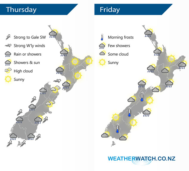
A blustery west to southwest airflow lies over New Zealand today, within this flow a cold front moves onto the lower South Island this morning reaching the lower North Island this evening. A more moderate southwesterly airflow lies over New Zealand on Friday moving around a large high pressure system in the Tasman Sea.
A shower or two for the western North Island today, especially this morning. Sunnier conditions in the east. The West Coast of the South Island sees rain or showers, rain about Southland spreads into Otago this morning then Canterbury this afternoon with a chance of heavy falls. Conditions ease overnight. West to southwesterly winds for the South Island especially about coastal areas will be strong with a risk of gales.
The odd shower clears the western North Island on Friday morning, not clearing Northland till evening. The Waikato and Bay Of Plenty have a mainly sunny day. The odd shower about eastern coastal fringes clears in the evening (Gisborne to Wairarapa). The South Island is mainly sunny for the majority…. however, some morning cloud and the risk of a shower clears Buller. Showers clear Banks Peninsula in the afternoon. Some coastal cloud hangs about Southland and Otago during the day. A chilly start to the day for inland areas.
By Weather Analyst Aaron Wilkinson – WeatherWatch.co.nz
Latest Video

Cold weekend, frosts return with high pressure, then a low late next week
The subantarctic airflow spreads over NZ today/tonight and into Saturday, dropping temperatures nationwide. Snow flurries are possible today to lower…
Related Articles
Cold weekend, frosts return with high pressure, then a low late next week
The subantarctic airflow spreads over NZ today/tonight and into Saturday, dropping temperatures nationwide. Snow flurries are possible today to lower…

Wintry burst of weather: Snow, squally showers then sunshine & frosts
A polar change (another one!) arrives on Friday for the South Island and goes nationwide on Saturday, leaving NZ under…

Antarctic southerly for parts of NZ Fri & Sat
For the first time this year a southerly from off Antarctica is heading towards the South Island, followed by more…

